Geolocate

Newburg topographic map

Click on the map to display elevation.

About this map

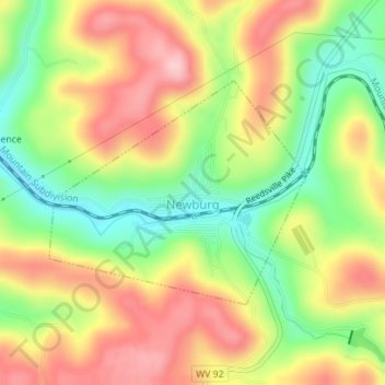
Name: Newburg topographic map, elevation, terrain.

Location: Newburg, Preston County, West Virginia, United States (39.38161 -79.86607 39.39732 -79.84278)

Average elevation: 451 m

Minimum elevation: 359 m

Maximum elevation: 541 m

Other topographic maps

Click on a map to view its topography, its elevation and its terrain.

Anderson

United States > West Virginia > Preston County

Average elevation: 573 m

Caddell

United States > West Virginia > Preston County

Average elevation: 487 m

Jessop

United States > West Virginia > Preston County

Average elevation: 616 m

Caddell

United States > West Virginia > Preston County

Average elevation: 487 m

Anderson

United States > West Virginia > Preston County

Average elevation: 573 m

Sell

United States > West Virginia > Preston County

Average elevation: 743 m

Victoria

United States > West Virginia > Preston County

Average elevation: 474 m

Preston

United States > West Virginia > Preston County > Preston

Average elevation: 502 m

Gear up for your next adventure:

🧰Multitool Knife - Compact and versatile tool for outdoor use
🧢Sun Protection Cap - Breathable cap to protect from sun exposure
🧳Compression Sacks - Maximize space in your backpack by shrinking gear
🚲Handlebar Phone Mount - View topographic-map.com live while cycling
🧥Softshell Hiking Jacket - The perfect balance of wind protection and breathability

As an Amazon Associate, this site earns from qualifying purchases at no extra cost to you.