Geolocate

Valley Point topographic map

Click on the map to display elevation.

About this map

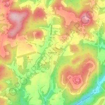
Name: Valley Point topographic map, elevation, terrain.

Location: Valley Point, Preston County, West Virginia, United States (39.56008 -79.65672 39.60008 -79.61672)

Average elevation: 596 m

Minimum elevation: 476 m

Maximum elevation: 687 m

Other topographic maps

Click on a map to view its topography, its elevation and its terrain.

Kingwood

United States > West Virginia > Preston County

Average elevation: 530 m

Kingwood

United States > West Virginia > Preston County

Average elevation: 530 m

Kingwood

United States > West Virginia > Preston County

Average elevation: 530 m

Masontown

United States > West Virginia > Preston County

Average elevation: 541 m

Masontown

United States > West Virginia > Preston County

Average elevation: 541 m

Newburg

United States > West Virginia > Preston County

Average elevation: 451 m

Gear up for your next adventure:

🥾Hiking Shorts - Breathable shorts suitable for summer hikes
🥾Trail Running Shoes - Lightweight and durable shoes for trail running
🛶Kayak Dry Bag - Waterproof storage for kayaking adventures
🥾Trail Running Boots - Durable shoes designed for trail running
🧭GPS Handheld Device - Reliable GPS navigation for outdoor adventures

As an Amazon Associate, this site earns from qualifying purchases at no extra cost to you.