Geolocate

Caddell topographic map

Click on the map to display elevation.

About this map

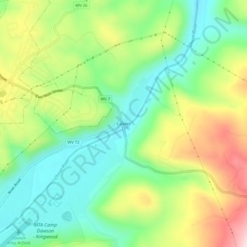
Name: Caddell topographic map, elevation, terrain.

Location: Caddell, Preston County, West Virginia, 26537, United States (39.44315 -79.67033 39.48315 -79.63033)

Average elevation: 487 m

Minimum elevation: 355 m

Maximum elevation: 699 m

Other topographic maps

Click on a map to view its topography, its elevation and its terrain.

Kingwood

United States > West Virginia > Preston County

Average elevation: 530 m

Kingwood

United States > West Virginia > Preston County

Average elevation: 530 m

Kingwood

United States > West Virginia > Preston County

Average elevation: 530 m

Masontown

United States > West Virginia > Preston County

Average elevation: 541 m

Masontown

United States > West Virginia > Preston County

Average elevation: 541 m

Newburg

United States > West Virginia > Preston County

Average elevation: 451 m

Gear up for your next adventure:

🧢Hiking Hat - Sun-protective and breathable hats for long treks
🧴Sunscreen SPF - Broad-spectrum sunscreen for outdoor activities
🔦LED Headtorch - Bright and durable light for night activities
Bushcraft Tarp - Versatile emergency shelter or gear protection
🧢Hiking Sun Hat - Wide-brimmed protection for exposed mountain ridges

As an Amazon Associate, this site earns from qualifying purchases at no extra cost to you.