
Angoon topographic map
Click on the map to display elevation.
About this map
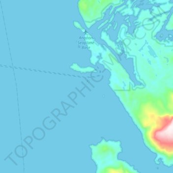
Name: Angoon topographic map, elevation, terrain.
Location: Angoon, Unorganized Borough, Alaska, 99820, United States (57.37612 -134.63979 57.53196 -134.36101)
Average elevation: 38 m
Minimum elevation: -6 m
Maximum elevation: 903 m
Other topographic maps
Click on a map to view its topography, its elevation and its terrain.
Akiak
United States > Alaska > Unorganized Borough
The airport has a gravel runway in good condition, measuring 3,196 feet (974 m) long by 75 feet (23 m) wide, at an elevation of 30 feet (9.1 m). The strip provides chartered or private air access year-round. Arctic Circle Air Service, Grant Aviation, and Hageland Aviation offer passenger flight service. Snow…
Average elevation: 5 m
Paxson
United States > Alaska > Unorganized Borough
Paxson has a continental subarctic climate (Köppen Dfc), closely bordering on an alpine climate (Köppen ET) due to its high elevation and northerly latitude, with only one month above the 50 degree isotherm.
Average elevation: 1,015 m
Mount Crillon
United States > Alaska > Unorganized Borough
Mount Crillon is not climbed frequently, since it is an extremely challenging climb for its elevation due to its isolation. The first ascent was in 1934, by explorer Bradford Washburn on his third attempt, and longtime editor of the American Alpine Journal H. Adams Carter. They climbed via the East Ridge above…
Average elevation: 2,891 m
Chevak
United States > Alaska > Unorganized Borough
Chevak first appeared on the 1940 U.S. Census as an unincorporated native village. At the time it was located above the junction of the Keoklevik & Kashunuk Rivers at an altitude of 7 feet. 61°25′56″N 165°27′03″W / 61.43222°N 165.45083°W / 61.43222; -165.45083 (Old Chevak) In the 1940s,…
Average elevation: 8 m
Mount Hayes
United States > Alaska > Unorganized Borough
Mount Hayes is the highest mountain in the eastern Alaska Range, in the U.S. state of Alaska. Despite not being a fourteener, it is one of the largest peaks in the United States in terms of rise above local terrain. For example, the Northeast Face rises 8,000 feet (2,440 m) in approximately 2 miles (3.2 km).…
Average elevation: 3,235 m
Central
United States > Alaska > Unorganized Borough
Central is located at 65°32′0″N 144°41′44″W / 65.53333°N 144.69556°W / 65.53333; -144.69556 (65.533461, -144.695650). The elevation is 942 feet. The Steese Highway (Alaska Route 6) does pass through Central.
Average elevation: 482 m
Lituya Bay
United States > Alaska > Unorganized Borough
The same topography that leads to the heavy tidal currents also created the tsunami with the highest runup against a hillside in recorded history. On July 9, 1958, an earthquake caused a landslide in the Gilbert Inlet at the head of the bay, generating a massive megatsunami which had sufficient energy to run…
Average elevation: 217 m