Geolocate

Bethel topographic map

Click on the map to display elevation.

About this map

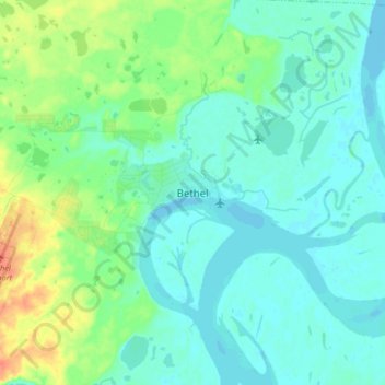
Name: Bethel topographic map, elevation, terrain.

Location: Bethel, Unorganized Borough, Alaska, United States (60.75222 -161.79583 60.83222 -161.71583)

Average elevation: 9 m

Minimum elevation: -3 m

Maximum elevation: 39 m

Gear up for your next adventure:

🥾Lightweight Hiking Shoes - Comfortable shoes for day hikes
🔦LED Headlamp - Hands-free lighting for early morning starts or late finishes
🧢Beanie Hat - Keep your head warm in cold weather
🦯Trekking Poles - Reduced impact on joints for steep topographic climbs
🧢Outdoor Visor - Breathable visor for sunny hikes

As an Amazon Associate, this site earns from qualifying purchases at no extra cost to you.