Geolocate

Saylorville topographic map

Click on the map to display elevation.

About this map
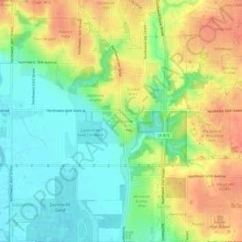
Name: Saylorville topographic map, elevation, terrain.

Location: Saylorville, Saylor Township, Polk County, Iowa, 50313, United States (41.65860 -93.64966 41.69860 -93.60966)

Average elevation: 266 m

Minimum elevation: 243 m

Maximum elevation: 292 m

Other topographic maps

Click on a map to view its topography, its elevation and its terrain.

Des Moines

United States > Iowa > Polk County

Average elevation: 264 m

West Des Moines

United States > Iowa > Polk County

Average elevation: 280 m

Ankeny

United States > Iowa > Polk County

Like most of Polk County, Iowa, Ankeny exists at the bottom area of the Des Moines Lobe, a topographical landscape area, in an area known as the Bemis Advance. The Lobe was formed during the Wisconsin glaciation leaving significant deposits resulting in an area with low relief.

Average elevation: 284 m

Urbandale

United States > Iowa > Polk County

Average elevation: 279 m

Johnston

United States > Iowa > Polk County

Average elevation: 267 m

Elkhart

United States > Iowa > Polk County

Average elevation: 294 m

Polk City

United States > Iowa > Polk County

Average elevation: 283 m

Clive

United States > Iowa > Polk County

Average elevation: 287 m

Des Moines

United States > Iowa > Polk County

Average elevation: 264 m

Grimes

United States > Iowa > Polk County

Average elevation: 292 m

Ankeny

United States > Iowa > Polk County

Like most of Polk County, Ankeny exists at the bottom area of the Des Moines Lobe, a topographical landscape area, in an area known as the Bemis Advance. The Lobe was formed during the Wisconsin glaciation leaving significant deposits resulting in an area with low relief.

Average elevation: 284 m

Runnells

United States > Iowa > Polk County

Average elevation: 246 m

Des Moines

United States > Iowa > Polk County

Average elevation: 265 m

Des Moines

United States > Iowa > Polk County

Average elevation: 265 m

Mitchellville

United States > Iowa > Polk County

Average elevation: 287 m

Polk City

United States > Iowa > Polk County

Average elevation: 283 m

West Des Moines

United States > Iowa > Polk County

Average elevation: 280 m

Clive

United States > Iowa > Polk County

Average elevation: 287 m

Altoona

United States > Iowa > Polk County

Average elevation: 286 m

Des Moines

United States > Iowa > Polk County

Average elevation: 265 m

Des Moines

United States > Iowa > Polk County

Average elevation: 264 m

Des Moines

United States > Iowa > Polk County

Average elevation: 265 m

Des Moines

United States > Iowa > Polk County

Average elevation: 265 m

West Des Moines

United States > Iowa > Polk County

Average elevation: 280 m

West Des Moines

United States > Iowa > Polk County

Average elevation: 280 m

Clive

United States > Iowa > Polk County

Average elevation: 287 m

Gear up for your next adventure:

🥾Trail Hiking Boots - Supportive boots for rough trails
🏃Hydration Running Vest - Carry water and maps close to your body for speed
🧢Outdoor Cap - Protective cap for sun and rain during hikes
🚲MTB Frame Bag - Carry tools and maps directly on your bicycle frame
⛺Backpacking Tent - Lightweight tent for long-distance hiking trips

As an Amazon Associate, this site earns from qualifying purchases at no extra cost to you.