Geolocate

Magreglio topographic map

Click on the map to display elevation.

About this map

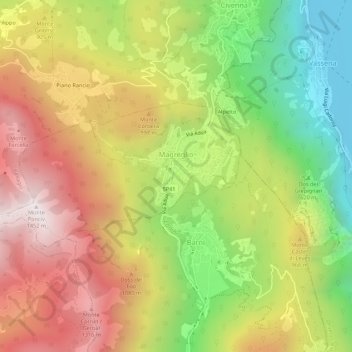
Name: Magreglio topographic map, elevation, terrain.

Location: Magreglio, Como, Lombardy, Italy (45.91053 9.21787 45.92628 9.27216)

Average elevation: 827 m

Minimum elevation: 196 m

Maximum elevation: 1,453 m

Other topographic maps

Click on a map to view its topography, its elevation and its terrain.

Carcente

Italy > Lombardy > Como > San Siro > Acquaseria

Average elevation: 693 m

Auvrascio

Italy > Lombardy > Como > Schignano > Occagno

Average elevation: 769 m

Lenno

Italy > Lombardy > Como > Tremezzina

Average elevation: 382 m

Lanzo d'Intelvi

Italy > Lombardy > Como

Average elevation: 863 m

Rovenna

Italy > Lombardy > Como

Average elevation: 449 m

San Fedele Intelvi

Italy > Lombardy > Como

Average elevation: 828 m

Dicinisio

Italy > Lombardy > Como

Average elevation: 831 m

Naggio

Italy > Lombardy > Como > Grandola ed Uniti

Average elevation: 651 m

San Giorgio

Italy > Lombardy > Como > Solbiate con Cagno > Concagno

Average elevation: 400 m

Parè

Italy > Lombardy > Como > Colverde

Average elevation: 386 m

Casasco d'Intelvi

Italy > Lombardy > Como

Average elevation: 853 m

Gear up for your next adventure:

💧Reusable Water Bottle - Durable water bottles for hydration on trails
🧭Orienteering Kit - Tools for map reading and navigation in the wild
🦯Trekking Poles - Reduced impact on joints for steep topographic climbs
🧢Sun Protection Cap - Breathable cap to protect from sun exposure
🧤Thermal Hiking Gloves - Grip-enhanced gloves for cold-weather altitude trekking

As an Amazon Associate, this site earns from qualifying purchases at no extra cost to you.