Geolocate

San Fedele Intelvi topographic map

Click on the map to display elevation.

About this map

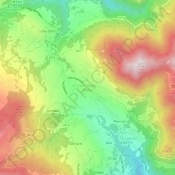
Name: San Fedele Intelvi topographic map, elevation, terrain.

Location: San Fedele Intelvi, Centro Valle Intelvi, Como, Lombardy, 22028, Italy (45.94717 9.05788 45.98717 9.09788)

Average elevation: 828 m

Minimum elevation: 457 m

Maximum elevation: 1,263 m

Other topographic maps

Click on a map to view its topography, its elevation and its terrain.

Lake Como

Italy > Lombardy > Como

Lake Como weather is humid subtropical (Cfa in the Köppen climate classification). In winter, the lake helps to maintain a higher temperature in the surrounding region. Average daily temperatures range from ~3.7 °C (39 °F) in January to 23.4 °C (74 °F) in July, according to historical weather data from…

Average elevation: 885 m

Menaggio

Italy > Lombardy > Como

Average elevation: 350 m

Sormano

Italy > Lombardy > Como

Average elevation: 943 m

Magreglio

Italy > Lombardy > Como

Average elevation: 827 m

Campione d'Italia

Italy > Lombardy > Como > Campione d'Italia

Average elevation: 438 m

Gear up for your next adventure:

🎒Fully Waterproof Backpack - Total protection for photography gear and electronics
🧤Thermal Hiking Gloves - Grip-enhanced gloves for cold-weather altitude trekking
🧰Multitool Knife - Compact and versatile tool for outdoor use
🎒Backpack Rain Cover - External shield to keep your entire pack dry
🕶️Polarized Sunglasses - Reduces glare from snow and water at high elevations

As an Amazon Associate, this site earns from qualifying purchases at no extra cost to you.