Geolocate

Fließ topographic map

Click on the map to display elevation.

About this map

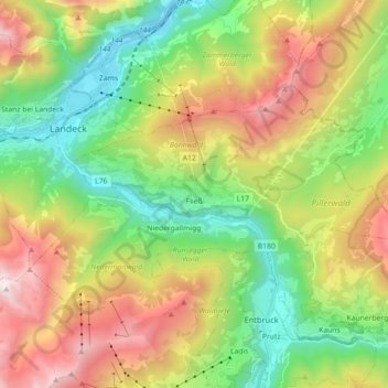
Name: Fließ topographic map, elevation, terrain.

Location: Fließ, Bezirk Landeck, Tyrol, 6521, Austria (47.08741 10.55236 47.15596 10.73136)

Average elevation: 1,553 m

Minimum elevation: 750 m

Maximum elevation: 2,804 m

Other topographic maps

Click on a map to view its topography, its elevation and its terrain.

Nasserein

Austria > Tyrol > Bezirk Landeck > Sankt Jakob am Arlberg

Average elevation: 1,702 m

Gand

Austria > Tyrol > Bezirk Landeck > Sankt Jakob am Arlberg

Average elevation: 1,658 m

Gand

Austria > Tyrol > Bezirk Landeck > Sankt Jakob am Arlberg

Average elevation: 1,658 m

Madau

Austria > Tyrol > Bezirk Landeck

Average elevation: 1,780 m

Pfannknecht

Austria > Tyrol > Bezirk Landeck > Galtür

Average elevation: 2,605 m

Komperdell

Austria > Tyrol > Bezirk Landeck > Serfaus

Average elevation: 2,012 m

Tscheyegg

Austria > Tyrol > Bezirk Landeck > Gemeinde Nauders

Average elevation: 2,409 m

Sankt Jakob am Arlberg

Austria > Tyrol > Bezirk Landeck

Average elevation: 1,667 m

Perjen

Austria > Tyrol > Bezirk Landeck > Stadt Landeck > Landeck > Perjen

Average elevation: 1,090 m

Gear up for your next adventure:

🩹Compact First Aid Kit - Pre-packed essentials for common trail injuries
💧Collapsible Water Bottle - Space-saving water bottle for outdoor activities
💧Hydration Pack - Hands-free hydration system for long hikes
🏃Hydration Running Vest - Carry water and maps close to your body for speed
❄️Traction Ice Cleats - Slip-on spikes for icy trails and winter hiking

As an Amazon Associate, this site earns from qualifying purchases at no extra cost to you.