Geolocate

Tsiigehtchic topographic map

Click on the map to display elevation.

About this map

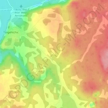
Name: Tsiigehtchic topographic map, elevation, terrain.

Location: Tsiigehtchic, Northwest Territories, X0E 0B0, Canada (67.42193 -133.76902 67.44992 -133.70361)

Average elevation: 59 m

Minimum elevation: -7 m

Maximum elevation: 106 m

Northwest Territories trails, hiking, mountain biking, running and outdoor activities

Other topographic maps

Click on a map to view its topography, its elevation and its terrain.

Mackenzie Mountains

Canada > Northwest Territories

Average elevation: 1,213 m

North Nahanni River

Canada > Northwest Territories

Average elevation: 1,449 m

Inuvik

Canada > Northwest Territories

Average elevation: 159 m

Peel River

Canada > Northwest Territories

Average elevation: 45 m

Wrigley

Canada > Northwest Territories > Dehcho Region

Average elevation: 159 m

Grace Lake

Canada > Northwest Territories > Yellowknife

Average elevation: 183 m

Déline

Canada > Northwest Territories > Sahtu Region

Average elevation: 193 m

Yellowknife

Canada > Northwest Territories > Yellowknife

Average elevation: 182 m

Gear up for your next adventure:

🥾Hiking Leggings - Comfortable leggings for outdoor activities
🕶️Polarized Sunglasses - Reduces glare from snow and water at high elevations
🥾Light Hiking Boots - Lightweight and comfortable boots for day hikes
Bushcraft Tarp - Versatile emergency shelter or gear protection
Lightweight Backpacking Tent - Compact tent for efficient hiking trips

As an Amazon Associate, this site earns from qualifying purchases at no extra cost to you.