Geolocate

Rabbitkettle Lake topographic map

Click on the map to display elevation.

About this map

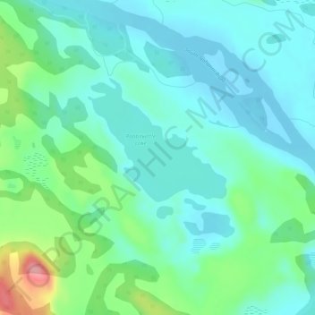
Name: Rabbitkettle Lake topographic map, elevation, terrain.

Location: Rabbitkettle Lake, Dehcho Region, Northwest Territories, Canada (61.96135 -127.21955 61.96145 -127.21945)

Average elevation: 628 m

Minimum elevation: 602 m

Maximum elevation: 715 m

Dehcho Region trails, hiking, mountain biking, running and outdoor activities

Other topographic maps

Click on a map to view its topography, its elevation and its terrain.

Wrigley

Canada > Northwest Territories > Dehcho Region

Average elevation: 159 m

Gear up for your next adventure:

🛏️Camping Sleeping Mat - Comfortable mats for sleeping outdoors
🧰Survival Kit - Essential gear for emergencies in the wilderness
💡LED Headlamp - Hands-free illumination for night hiking and camping
🎒Hiking Daypack - Lightweight and durable backpacks for day trips and excursions
🥾Trekking Poles - Adjustable trekking poles to reduce knee stress and improve stability

As an Amazon Associate, this site earns from qualifying purchases at no extra cost to you.