
Make a donation
Gear up for your next adventure:
As an Amazon Associate, this site earns from qualifying purchases at no extra cost to you.
Freiburg Alps topographic map
Click on the map to display elevation.
Make a donation
Gear up for your next adventure:
As an Amazon Associate, this site earns from qualifying purchases at no extra cost to you.
About this map
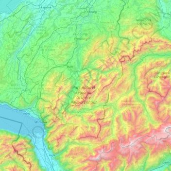
Name: Freiburg Alps topographic map, elevation, terrain.
Location: Freiburg Alps, Fribourg, Switzerland (46.31679 6.80875 46.79103 7.65458)
Average elevation: 1,174 m
Minimum elevation: 367 m
Maximum elevation: 3,220 m
Make a donation
Gear up for your next adventure:
As an Amazon Associate, this site earns from qualifying purchases at no extra cost to you.
Other topographic maps
Click on a map to view its topography, its elevation and its terrain.
Forel
Switzerland > Fribourg > District de la Broye > Estavayer > Vernay > Forel
Average elevation: 458 m
Villaz-Saint-Pierre
Switzerland > Fribourg > District de la Glâne > Villaz > Villaz-Saint-Pierre
Average elevation: 727 m
Make a donation
Gear up for your next adventure:
As an Amazon Associate, this site earns from qualifying purchases at no extra cost to you.
Make a donation
Gear up for your next adventure:
As an Amazon Associate, this site earns from qualifying purchases at no extra cost to you.