
Thank you for supporting this site ❤️
Make a donation
Make a donation
Gear up for your next adventure:
As an Amazon Associate, this site earns from qualifying purchases at no extra cost to you.
Liebistorf topographic map
Click on the map to display elevation.
Thank you for supporting this site ❤️
Make a donation
Make a donation
Gear up for your next adventure:
As an Amazon Associate, this site earns from qualifying purchases at no extra cost to you.
About this map
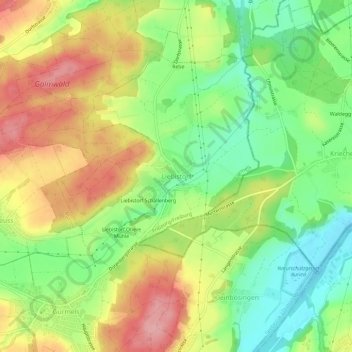
Name: Liebistorf topographic map, elevation, terrain.
Location: Liebistorf, Gurmels, See District, Fribourg, 3213, Switzerland (46.88820 7.17416 46.92820 7.21416)
Average elevation: 544 m
Minimum elevation: 485 m
Maximum elevation: 610 m
Thank you for supporting this site ❤️
Make a donation
Make a donation
Gear up for your next adventure:
As an Amazon Associate, this site earns from qualifying purchases at no extra cost to you.