Geolocate

Piovene Rocchette topographic map

Click on the map to display elevation.

About this map

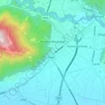
Name: Piovene Rocchette topographic map, elevation, terrain.

Location: Piovene Rocchette, Vicenza, Veneto, 36013, Italy (45.72914 11.39251 45.77823 11.45069)

Average elevation: 335 m

Minimum elevation: 171 m

Maximum elevation: 1,225 m

Other topographic maps

Click on a map to view its topography, its elevation and its terrain.

Rotz

Italy > Veneto > Vicenza > Gallio

Average elevation: 1,167 m

La Gusela

Italy > Veneto > Vicenza > Cismon del Grappa

Average elevation: 556 m

San Pietro

Italy > Veneto > Vicenza

Average elevation: 832 m

Fosse di Sopra

Italy > Veneto > Vicenza > Enego

Average elevation: 680 m

Arso

Italy > Veneto > Vicenza > Chiampo

Average elevation: 425 m

Axe

Italy > Veneto > Vicenza > Posina

Average elevation: 880 m

Località Casoni

Italy > Veneto > Vicenza > Marano Vicentino

Average elevation: 154 m

Troio

Italy > Veneto > Vicenza > Lusiana

Average elevation: 813 m

Villa di Fimon

Italy > Veneto > Vicenza > Fimon

Average elevation: 230 m

Sette

Italy > Veneto > Vicenza > San Vito di Leguzzano

Average elevation: 234 m

Frisoni

Italy > Veneto > Vicenza > Stoner

Average elevation: 1,096 m

Campanella

Italy > Veneto > Vicenza

Average elevation: 582 m

Staro

Italy > Veneto > Vicenza

Average elevation: 645 m

Clama

Italy > Veneto > Vicenza > Asiago > Clama

Average elevation: 1,055 m

Gear up for your next adventure:

🧦Hiking Socks - Moisture-wicking and comfortable socks for long hikes
🔋Emergency Crank Radio - Weather alerts and power without needing batteries
🧳Compression Sacks - Maximize space in your backpack by shrinking gear
🧰Multitool Knife - Compact and versatile tool for outdoor use
🛶Kayak Accessories - Essential gear for safe and fun kayaking adventures

As an Amazon Associate, this site earns from qualifying purchases at no extra cost to you.