Geolocate

Axe topographic map

Click on the map to display elevation.

About this map

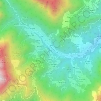
Name: Axe topographic map, elevation, terrain.

Location: Axe, Posina, Vicenza, Veneto, Italy (45.77183 11.22621 45.81183 11.26621)

Average elevation: 880 m

Minimum elevation: 495 m

Maximum elevation: 1,734 m

Gear up for your next adventure:

🧭GPS Outdoor Watch - Smart watch for navigation and fitness tracking in nature
🥤Collapsible Travel Cup - Saves space and weight in your mess kit
🧢Hiking Sun Hat - Wide-brimmed protection for exposed mountain ridges
🥾Trekking Boots - Durable boots for long-distance trekking
🥫Freeze-Dried Meals - Lightweight, high-calorie nutrition for multi-day treks

As an Amazon Associate, this site earns from qualifying purchases at no extra cost to you.