Geolocate

Sette topographic map

Click on the map to display elevation.

About this map

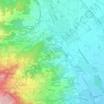
Name: Sette topographic map, elevation, terrain.

Location: Sette, San Vito di Leguzzano, Vicenza, Veneto, 36034, Italy (45.65441 11.35207 45.69441 11.39207)

Average elevation: 234 m

Minimum elevation: 113 m

Maximum elevation: 603 m

Gear up for your next adventure:

🥾Hiking Shoes - Durable and comfortable shoes for trail hiking
🥾All-Terrain Hiking Boots - Versatile boots for varied hiking conditions
🪜Heavy Duty Carabiners - Multi-use clips for securing gear to your backpack
🔥Emergency Fire Starter - Reliable ignition source for all weather conditions
🥾Mountain Hiking Shoes - Shoes with superior grip for mountainous terrain

As an Amazon Associate, this site earns from qualifying purchases at no extra cost to you.