
Town of Trenton topographic map
Interactive map
Click on the map to display elevation.
About this map
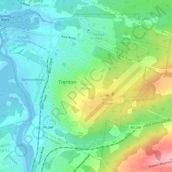
Name: Town of Trenton topographic map, elevation, terrain.
Location: Town of Trenton, Pictou County, Nova Scotia, Canada (45.59953 -62.65118 45.62696 -62.60580)
Average elevation: 45 m
Minimum elevation: -1 m
Maximum elevation: 146 m
Nova Scotia trails, hiking, mountain biking, running and outdoor activities
Other topographic maps
Click on a map to view its topography, its elevation and its terrain.
Annapolis Valley
Canada > Nova Scotia > Municipality of the County of Kings > Auburn
Average elevation: 77 m
Lansdowne Lake
Canada > Nova Scotia > Municipality of Pictou County > New Lairg
Average elevation: 160 m
Meadows Road
Canada > Nova Scotia > Cape Breton Regional Municipality > Sydney Forks
Average elevation: 23 m
Two Rivers
Canada > Nova Scotia > Municipality of the County of Cumberland > Joggins
Average elevation: 52 m
Cape Chignecto
Canada > Nova Scotia > Municipality of the County of Cumberland > Cape Chignecto Provincial Park
Average elevation: 20 m
Comeau Point
Canada > Nova Scotia > Municipality of the County of Richmond > Alderney Point
Average elevation: 11 m
Victoria Bridge
Canada > Nova Scotia > Cape Breton Regional Municipality > Upper Grand Mira
Average elevation: 17 m
Glasgow Mountain
Canada > Nova Scotia > Municipality of the County of Cumberland > Diligent River
Average elevation: 143 m
Loon Lake Channel
Canada > Nova Scotia > Municipality of the County of Kings > Aylesford Lake
Average elevation: 220 m
Garrets Lake
Canada > Nova Scotia > Municipality of the County of Richmond > Salmon River
Average elevation: 48 m
White Hill
Canada > Nova Scotia > Cape Breton Highlands National Park > Cape Breton Highlands National Park
White Hill is a peak in the Cape Breton Highlands and is the highest elevation point in the province of Nova Scotia, Canada.
Average elevation: 488 m
Centreville
Canada > Nova Scotia > Cape Breton Regional Municipality > Sydney Mines
Average elevation: 12 m
Boularderie
Canada > Nova Scotia > Municipality of Victoria County > Ross Ferry
Average elevation: 50 m
Meat Cove
Canada > Nova Scotia > Municipality of the County of Inverness > Meat Cove
Average elevation: 117 m
Larry's River
Canada > Nova Scotia > Guysborough District Municipality > Larrys River
Average elevation: 5 m
Starrs Point
Canada > Nova Scotia > Municipality of the County of Kings > Port Williams
Average elevation: 3 m
Sporting Mountain
Canada > Nova Scotia > Municipality of the County of Richmond > River Bourgeois
Average elevation: 59 m
River Philip Centre
Canada > Nova Scotia > Municipality of the County of Cumberland
Average elevation: 85 m
Roundhill Lakes
Canada > Nova Scotia > Municipality of Victoria County > Cape Breton Highlands National Park
Average elevation: 427 m
Cranberry Lake
Canada > Nova Scotia > Cape Breton Regional Municipality > Enon
Average elevation: 103 m
Chignecto Isthmus
Canada > Nova Scotia > Municipality of the County of Cumberland > Fort Lawrence
Average elevation: 14 m
Shingle Lake
Canada > Nova Scotia > Guysborough District Municipality > Forest Hill
Average elevation: 124 m
Upper Glencoe
Canada > Nova Scotia > Municipality of the County of Inverness > Glencoe
Average elevation: 181 m
Mersey River
Canada > Nova Scotia > Queens County > Kejimkujik National Park of Canada
Average elevation: 93 m
Frasertown
Canada > Nova Scotia > Municipality of the County of Annapolis > Princedale
Average elevation: 138 m
Westchester Valley
Canada > Nova Scotia > Municipality of the County of Cumberland
Average elevation: 194 m
Upper Kempt Head
Canada > Nova Scotia > Municipality of Victoria County > Kempt Head
Average elevation: 20 m
Long Point Provincial Park
Canada > Nova Scotia > Municipality of the County of Inverness > Long Point
Average elevation: 32 m
Cape Split
Canada > Nova Scotia > Municipality of the County of Kings > Scots Bay
Average elevation: 6 m
The Lookoff
Canada > Nova Scotia > Municipality of Victoria County > Forks Baddeck
Average elevation: 301 m
Blue Sea Corner
Canada > Nova Scotia > Municipality of the County of Cumberland > Malagash Point
Average elevation: 11 m
Gaspereau Mountain
Canada > Nova Scotia > Municipality of the County of Kings > Forest Hill
Average elevation: 185 m
Mullins Point
Canada > Nova Scotia > Municipality of the County of Cumberland > North Wallace
Average elevation: 2 m
Salmon River Road
Canada > Nova Scotia > Cape Breton Regional Municipality > Grand Mira North
Average elevation: 18 m
Cape Split
Canada > Nova Scotia > Queens County > Kejimkujik National Park of Canada
Average elevation: 130 m
Mitchells Beach
Canada > Nova Scotia > Municipality of the County of Cumberland > West Pugwash
Average elevation: 7 m