Geolocate

Glade Spring topographic map

Click on the map to display elevation.

Glade Spring

The elevation is 2,087 ft above sea level.

Wikipedia (CC-BY-SA 3.0)

About this map

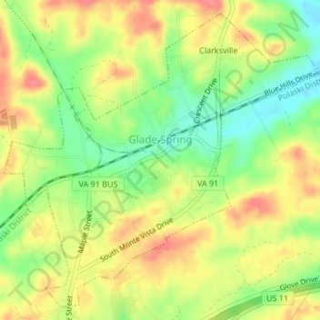
Name: Glade Spring topographic map, elevation, terrain.

Location: Glade Spring, Washington County, Virginia, United States (36.77707 -81.78774 36.80182 -81.75442)

Average elevation: 658 m

Minimum elevation: 620 m

Maximum elevation: 692 m

Other topographic maps

Click on a map to view its topography, its elevation and its terrain.

Pine Grove

United States > Virginia > Washington County

Average elevation: 532 m

Meadowview

United States > Virginia > Washington County

Average elevation: 658 m

Booker

United States > Virginia > Washington County

Average elevation: 600 m

Konnarock

United States > Virginia > Washington County > Konnarock

Average elevation: 1,005 m

Gear up for your next adventure:

❄️Traction Ice Cleats - Slip-on spikes for icy trails and winter hiking
🧥Softshell Jacket - Windproof and breathable jacket for hiking
🧭Orienteering Kit - Tools for map reading and navigation in the wild
🧥Waterproof Hiking Jacket - Protect yourself from rain and wind while hiking
🚲MTB Frame Bag - Carry tools and maps directly on your bicycle frame

As an Amazon Associate, this site earns from qualifying purchases at no extra cost to you.