Geolocate

High Meadows topographic map

Click on the map to display elevation.

About this map

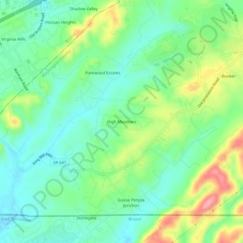
Name: High Meadows topographic map, elevation, terrain.

Location: High Meadows, Washington County, Virginia, United States (36.59011 -82.12541 36.63011 -82.08541)

Average elevation: 585 m

Minimum elevation: 544 m

Maximum elevation: 668 m

Gear up for your next adventure:

💡Compact LED Flashlight - Powerful and portable flashlight for outdoor use
🔋Solar Power Bank - Keep your GPS and devices charged during long outdoor trips
🥤Collapsible Travel Cup - Saves space and weight in your mess kit
🔋Lithium AA Batteries - Long-lasting power that performs in extreme cold
🥾Mountain Trail Shoes - High-traction shoes for mountain trails

As an Amazon Associate, this site earns from qualifying purchases at no extra cost to you.