Geolocate

Hilly topographic map

Click on the map to display elevation.

About this map

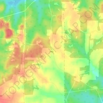
Name: Hilly topographic map, elevation, terrain.

Location: Hilly, Lincoln Parish, Louisiana, 71235, United States (32.62848 -92.69848 32.66848 -92.65848)

Average elevation: 65 m

Minimum elevation: 31 m

Maximum elevation: 91 m

Other topographic maps

Click on a map to view its topography, its elevation and its terrain.

Ruston

United States > Louisiana > Lincoln Parish

Average elevation: 82 m

Dubach

United States > Louisiana > Lincoln Parish

Average elevation: 46 m

Grambling

United States > Louisiana > Lincoln Parish

Average elevation: 90 m

Ruston

United States > Louisiana > Lincoln Parish

Average elevation: 82 m

Gear up for your next adventure:

🧦Hiking Liner Socks - Thin base layer to prevent friction and blisters
🧦Hiking Socks - Moisture-wicking and comfortable socks for long hikes
🧥Ultralight Puffy Jacket - Maximum warmth that packs down to the size of an orange
🛶Kayak Accessories - Essential gear for safe and fun kayaking adventures
🧢Hiking Sun Hat - Wide-brimmed protection for exposed mountain ridges

As an Amazon Associate, this site earns from qualifying purchases at no extra cost to you.