Geolocate

Grambling topographic map

Click on the map to display elevation.

About this map

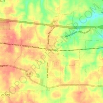
Name: Grambling topographic map, elevation, terrain.

Location: Grambling, Lincoln Parish, Louisiana, 71245, United States (32.50359 -92.73892 32.54979 -92.66940)

Average elevation: 90 m

Minimum elevation: 54 m

Maximum elevation: 115 m

Other topographic maps

Click on a map to view its topography, its elevation and its terrain.

Hilly

United States > Louisiana > Lincoln Parish

Average elevation: 65 m

Gear up for your next adventure:

🧥Packable Rain Jacket - Breathable waterproof layer for unpredictable weather
🥾Trail Running Shoes - Lightweight and durable shoes for trail running
🔥Camping Stove - Portable stoves to cook outdoors with ease
🥾Durable Hiking Shoes - Long-lasting shoes for frequent hiking
💡LED Headlamp - Hands-free illumination for night hiking and camping

As an Amazon Associate, this site earns from qualifying purchases at no extra cost to you.