Geolocate

Choudrant topographic map

Click on the map to display elevation.

About this map

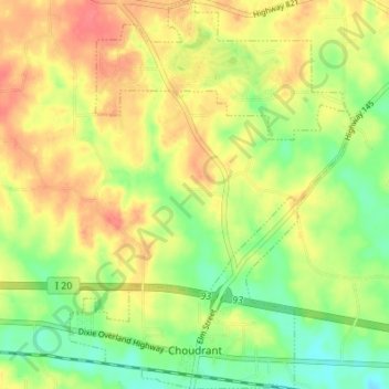
Name: Choudrant topographic map, elevation, terrain.

Location: Choudrant, Lincoln Parish, Louisiana, United States (32.52439 -92.53647 32.58204 -92.48660)

Average elevation: 65 m

Minimum elevation: 32 m

Maximum elevation: 97 m

Gear up for your next adventure:

🧣Merino Neck Gaiter - Protects against wind, sun, and cold at high altitudes
Camping Essentials - All-in-one gear for a comfortable camping trip
🥾Lightweight Hiking Boots - Boots for comfort and mobility on long hikes
🥾Mountain Hiking Shoes - Shoes with superior grip for mountainous terrain
Tent Footprint - Protect tent floor and increase durability

As an Amazon Associate, this site earns from qualifying purchases at no extra cost to you.