Geolocate

Ruston topographic map

Click on the map to display elevation.

About this map

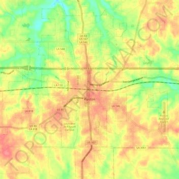
Name: Ruston topographic map, elevation, terrain.

Location: Ruston, Lincoln Parish, Louisiana, United States (32.48010 -92.68676 32.57714 -92.56913)

Average elevation: 82 m

Minimum elevation: 42 m

Maximum elevation: 112 m

Other topographic maps

Click on a map to view its topography, its elevation and its terrain.

Hilly

United States > Louisiana > Lincoln Parish

Average elevation: 65 m

Gear up for your next adventure:

🥫Freeze-Dried Meals - Lightweight, high-calorie nutrition for multi-day treks
🥾Waterproof Hiking Shoes - Durable shoes for wet and rugged trails
🧤Thermal Hiking Gloves - Grip-enhanced gloves for cold-weather altitude trekking
Camping Groundsheet - Protect your tent from moisture and dirt
💧Collapsible Water Bottle - Space-saving water bottle for outdoor activities

As an Amazon Associate, this site earns from qualifying purchases at no extra cost to you.