
White Dome Geyser topographic map
Interactive map
Click on the map to display elevation.
About this map
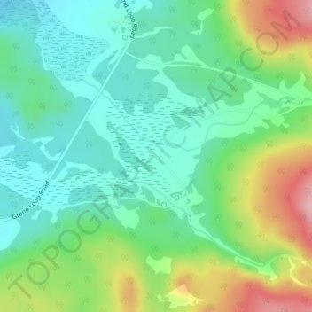
Name: White Dome Geyser topographic map, elevation, terrain.
Average elevation: 2,255 m
Minimum elevation: 2,202 m
Maximum elevation: 2,368 m
Other topographic maps
Click on a map to view its topography, its elevation and its terrain.
Rocky Mountains
United States > Wyoming > Teton County
Rocky Mountains, Teton County, Wyoming, United States
Average elevation: 2,292 m
Grand Prismatic Spring
United States > Wyoming > Teton County
Grand Prismatic Spring, Midway Geyser Basin, Teton County, Wyoming, United States
Average elevation: 2,237 m
Moose Mountain
United States > Wyoming > Teton County
Moose Mountain, Teton County, Wyoming, United States
Average elevation: 2,821 m
Yellowstone Caldera Supervolcano
United States > Wyoming > Teton County
Yellowstone Caldera Supervolcano, Teton County, Wyoming, United States
Average elevation: 2,530 m
West Thumb
United States > Wyoming > Teton County
West Thumb, Teton County, Wyoming, United States
Average elevation: 2,383 m
Phelps Lake
United States > Wyoming > Teton County
Phelps Lake, Teton County, Wyoming, United States
Average elevation: 2,084 m
Teton Village
United States > Wyoming > Teton County > Teton Village
Teton Village, Teton County, Wyoming, 83025, United States
Average elevation: 2,323 m
Battleship Mountain
United States > Wyoming > Teton County
Battleship Mountain, Teton County, Wyoming, United States
Average elevation: 2,924 m
Heart Lake
United States > Wyoming > Teton County
Heart Lake, Teton County, Wyoming, United States
Average elevation: 2,301 m
Grand Teton National Park
United States > Wyoming > Teton County
Grand Teton National Park, Teton County, Wyoming, United States
Average elevation: 2,409 m
Porcupine Hills
United States > Wyoming > Teton County
Porcupine Hills, Teton County, Wyoming, United States
Average elevation: 2,223 m