
Make a donation
Gear up for your next adventure:
As an Amazon Associate, this site earns from qualifying purchases at no extra cost to you.
Moose Mountain topographic map
Click on the map to display elevation.
Make a donation
Gear up for your next adventure:
As an Amazon Associate, this site earns from qualifying purchases at no extra cost to you.
About this map
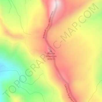
Name: Moose Mountain topographic map, elevation, terrain.
Location: Moose Mountain, Teton County, Wyoming, United States (43.93738 -110.85638 43.93748 -110.85628)
Average elevation: 2,821 m
Minimum elevation: 2,417 m
Maximum elevation: 3,152 m
Make a donation
Gear up for your next adventure:
As an Amazon Associate, this site earns from qualifying purchases at no extra cost to you.
Other topographic maps
Click on a map to view its topography, its elevation and its terrain.
Jackson
United States > Wyoming > Teton County
Jackson is located at an elevation of 6,237 feet (1,901 m) above sea level. According to the United States Census Bureau, the town has a total area of 2.95 square miles (7.64 km2), of which 2.91 square miles (7.54 km2) is land and 0.04 square miles (0.10 km2) is water.
Average elevation: 2,043 m