
Phelps Lake topographic map
Click on the map to display elevation.
About this map
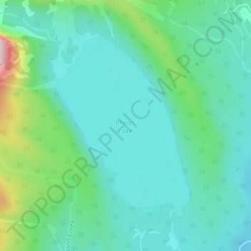
Name: Phelps Lake topographic map, elevation, terrain.
Location: Phelps Lake, Teton County, Wyoming, United States (43.63365 -110.80673 43.65314 -110.78695)
Average elevation: 2,084 m
Minimum elevation: 1,983 m
Maximum elevation: 2,440 m
Other topographic maps
Click on a map to view its topography, its elevation and its terrain.
Jackson
United States > Wyoming > Teton County
Jackson is located at an elevation of 6,237 feet (1,901 m) above sea level. According to the United States Census Bureau, the town has a total area of 2.95 square miles (7.64 km2), of which 2.91 square miles (7.54 km2) is land and 0.04 square miles (0.10 km2) is water.
Average elevation: 2,043 m