Geolocate

Locust Grove topographic map

Click on the map to display elevation.

About this map

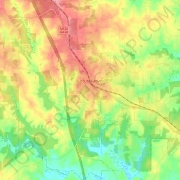
Name: Locust Grove topographic map, elevation, terrain.

Location: Locust Grove, Henry County, Georgia, 30248, United States (33.29763 -84.15044 33.38540 -84.05361)

Average elevation: 230 m

Minimum elevation: 185 m

Maximum elevation: 274 m

Other topographic maps

Click on a map to view its topography, its elevation and its terrain.

Whitehouse

United States > Georgia > Henry County

Average elevation: 230 m

Flippen

United States > Georgia > Henry County

Average elevation: 252 m

Fortson

United States > Georgia > Henry County > Hampton

Average elevation: 259 m

McDonough

United States > Georgia > Henry County > McDonough

Average elevation: 248 m

Ola

United States > Georgia > Henry County

Average elevation: 230 m

Kelleytown

United States > Georgia > Henry County

Average elevation: 220 m

Weems Lake

United States > Georgia > Henry County

Average elevation: 245 m

Hiram Cook Lake

United States > Georgia > Henry County

Average elevation: 248 m

Gear up for your next adventure:

🧥Waterproof Pants - Keep dry during rainy hiking conditions
Camping Groundsheet - Protect your tent from moisture and dirt
🥾Mountain Hiking Boots - High-traction boots for rocky terrain
🥾Mountain Hiking Shoes - Shoes with superior grip for mountainous terrain
🥾Waterproof Hiking Boots - Boots keeping your feet dry in wet conditions

As an Amazon Associate, this site earns from qualifying purchases at no extra cost to you.