Geolocate

Ola topographic map

Click on the map to display elevation.

About this map

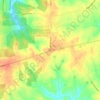
Name: Ola topographic map, elevation, terrain.

Location: Ola, Henry County, Georgia, United States (33.41595 -84.06186 33.45595 -84.02186)

Average elevation: 230 m

Minimum elevation: 199 m

Maximum elevation: 254 m

Other topographic maps

Click on a map to view its topography, its elevation and its terrain.

McDonough

United States > Georgia > Henry County

Average elevation: 249 m

Hampton

United States > Georgia > Henry County

Average elevation: 259 m

Locust Grove

United States > Georgia > Henry County

Average elevation: 230 m

Stockbridge

United States > Georgia > Henry County

Average elevation: 243 m

Heron Bay

United States > Georgia > Henry County

Average elevation: 237 m

Stockbridge

United States > Georgia > Henry County

Average elevation: 243 m

Hampton

United States > Georgia > Henry County

Average elevation: 259 m

McDonough

United States > Georgia > Henry County

Average elevation: 249 m

Gear up for your next adventure:

🔦UV Flashlight - Detect minerals or specific insects in the dark
💡LED Headlamp - Hands-free illumination for night hiking and camping
🥾Trail Hiking Shoes - Durable shoes designed for rugged trails
🗺️Topographic Maps - Detailed maps to explore trails, mountains, and wilderness areas
🚲Heavy Duty Bike Lock - Secure your bike at the trailhead or during stops

As an Amazon Associate, this site earns from qualifying purchases at no extra cost to you.