Geolocate

Peeksville topographic map

Click on the map to display elevation.

About this map

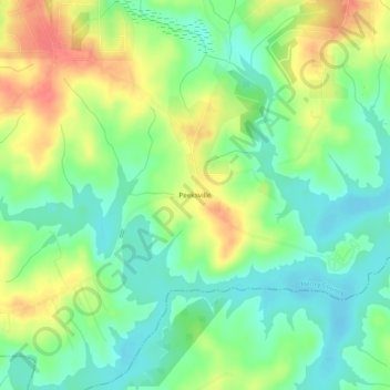
Name: Peeksville topographic map, elevation, terrain.

Location: Peeksville, Henry County, Georgia, United States (33.35817 -84.02463 33.39817 -83.98463)

Average elevation: 197 m

Minimum elevation: 172 m

Maximum elevation: 234 m

Other topographic maps

Click on a map to view its topography, its elevation and its terrain.

Stockbridge

United States > Georgia > Henry County

Average elevation: 243 m

McDonough

United States > Georgia > Henry County

Average elevation: 249 m

Stockbridge

United States > Georgia > Henry County

Average elevation: 243 m

Hampton

United States > Georgia > Henry County

Average elevation: 259 m

Hampton

United States > Georgia > Henry County

Average elevation: 259 m

McDonough

United States > Georgia > Henry County

Average elevation: 249 m

Gear up for your next adventure:

🦶Anti-Blister Balm - Prevents friction and hotspots during long ascents
🥾Hiking Boots - Sturdy boots providing ankle support and traction on rugged trails
🥾Hiking Shoes - Durable and comfortable shoes for trail hiking
🧼Biodegradable Camp Soap - Environmentally friendly cleaning for gear and body
🔦LED Flashlight - Powerful and long-lasting flashlight for camping and emergencies

As an Amazon Associate, this site earns from qualifying purchases at no extra cost to you.