
Make a donation
Gear up for your next adventure:
As an Amazon Associate, this site earns from qualifying purchases at no extra cost to you.
Bà Rịa topographic map
Click on the map to display elevation.
Make a donation
Gear up for your next adventure:
As an Amazon Associate, this site earns from qualifying purchases at no extra cost to you.
About this map
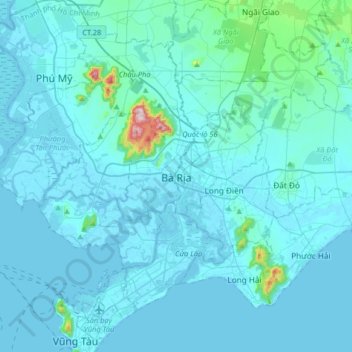
Name: Bà Rịa topographic map, elevation, terrain.
Location: Bà Rịa, Ho Chi Minh City, 78106, Vietnam (10.33724 107.00780 10.65724 107.32780)
Average elevation: 28 m
Minimum elevation: -4 m
Maximum elevation: 498 m
Make a donation
Gear up for your next adventure:
As an Amazon Associate, this site earns from qualifying purchases at no extra cost to you.
Other topographic maps
Click on a map to view its topography, its elevation and its terrain.
Bidoup - Nui Ba National Park
Vietnam > Lâm Đồng Province > Lạc Dương District
Average elevation: 1,312 m
Ho Chi Minh City
Ho Chi Minh City is located in the south-eastern region of Vietnam, 1,760 km (1,090 mi) south of Hanoi. The average elevation is 5 m (16 ft) above sea level for the city centre and 16 m (52 ft) for the suburb areas. It borders Tây Ninh Province and Bình Dương Province to the north, Đồng Nai Province and…
Average elevation: 26 m
Make a donation
Gear up for your next adventure:
As an Amazon Associate, this site earns from qualifying purchases at no extra cost to you.
Ho Chi Minh City
Ho Chi Minh City is located in the south-eastern region of Vietnam, 1,760 km (1,090 mi) south of Hanoi. The average elevation is 5 m (16 ft) above sea level for the city centre and 16 m (52 ft) for the suburb areas.[53] It borders Tây Ninh Province and Bình Dương Province to the north, Đồng Nai Province…
Average elevation: 26 m
Make a donation
Gear up for your next adventure:
As an Amazon Associate, this site earns from qualifying purchases at no extra cost to you.
Đà Nẵng
Geologically, Da Nang is at the edge of a Paleozoic fold belt known as the Truong Son Orogenic Zone, whose main deformation occurred during the early Carboniferous period. Da Nang's topography is dominated by the steep Annamite mountain range to the north and north-west, which features peaks ranging from 700…
Average elevation: 355 m
Make a donation
Gear up for your next adventure:
As an Amazon Associate, this site earns from qualifying purchases at no extra cost to you.
Thái Bình Province
The terrain of Thái Bình Province is relatively flat with a gradient of less than 1%; the common elevation ranges from 1–2 meters above sea level, gradually decreasing from the north to the southeast. Thái Bình has a coastline stretching 52 km.
Average elevation: 2 m
Quy Nhơn
Quy Nhon has a varied topography, being extremely diversified with mountains and forests, hills, fields, salt marshes, plains, lagoons, lakes, rivers, shorelines, peninsulas and islands. Its coastline is 42 kilometres or 26 miles long with sandy beaches, abundant seafood resources and other natural products of…
Average elevation: 86 m
Hue City
Vietnam > Thừa Thiên Huế Province
Located near Truong Son mountain range, Hue city is a plain area in the lower reaches of the Perfume and Bo rivers, with an average altitude of 3–4 m above sea level and often flooded when the river's headwaters Huong has medium and large rainfall. This plain area is relatively flat, although there are…
Average elevation: 24 m
Make a donation
Gear up for your next adventure:
As an Amazon Associate, this site earns from qualifying purchases at no extra cost to you.
Ninh Thuận Province
Ninh Thuận's topography is typical for the South Central Coast in that high mountains are located not only near the western border to the Central Highlands, but also near the coast, the highest of which is Chúa mountain (Vietnamese: Núi Chúa) at 1,040 metres (3,410 ft) in the north east of the province.…
Average elevation: 186 m
Make a donation
Gear up for your next adventure:
As an Amazon Associate, this site earns from qualifying purchases at no extra cost to you.
Ho Chi Minh City
The city is located in the south-eastern region of Vietnam, 1,760 km (1,090 mi) south of Hanoi. The average elevation is 5 m (16 ft) above sea level for the city centre and 16 m (52 ft) for the suburb areas. It borders Tây Ninh Province and Bình Dương Province to the north, Đồng Nai Province and Bà…
Average elevation: 17 m
Make a donation
Gear up for your next adventure:
As an Amazon Associate, this site earns from qualifying purchases at no extra cost to you.
Đà Nẵng
Geologically, Da Nang is at the edge of a Paleozoic fold belt known as the Truong Son Orogenic Zone, whose main deformation occurred during the early Carboniferous period. Da Nang's topography is dominated by the steep Annamite mountain range to the north and north-west, which features peaks ranging from 700…
Average elevation: 355 m
Bình Định Province
The majority of Bình Định province is covered by mountains or hills. Elevations range from 0 at the coast to around 1200 meters above sea level in An Lão district in the north-west of the province. While most of the mountains as well as the highest peaks are in the west, there are mountains throughout the…
Average elevation: 204 m
Kon Tum
Kon Tum City is situated in the southern part of Kon Tum Province, within a basin landscape at an elevation of approximately 525 meters above sea level. It is encircled by the Dak Bla River valley. The city is located 547 kilometers north of Ho Chi Minh City, 292 kilometers south of Da Nang, and 1,087…
Average elevation: 609 m
Make a donation
Gear up for your next adventure:
As an Amazon Associate, this site earns from qualifying purchases at no extra cost to you.
Điện Biên Province
Thẳm Khến Cave (also known locally as Chùa Ta Cave): Located at an altitude of nearly 1,000m above sea level, in a limestone mountain range with a geological tectonic process of millions of years, Tham Khen cave in Muong Dun commune, Tua Chua district has also been recognized by the Ministry of Culture.…
Average elevation: 897 m
Lào Cai Province
There are ten major soil groups under 30 categories in the province, under ten land groups. The land groups are: The Alluvial group (1.47% of the land area) along the Red River is good for growing food crops and trees; the Oxisol type which occupies 40% of land area has generally reddish brown soil, below…
Average elevation: 789 m
Make a donation
Gear up for your next adventure:
As an Amazon Associate, this site earns from qualifying purchases at no extra cost to you.
Ho Chi Minh City
The city is located in the south-eastern region of Vietnam, 1,760 km (1,090 mi) south of Hanoi. The average elevation is 5 m (16 ft) above sea level for the city centre and 16 m (52 ft) for the suburb areas. It borders Tây Ninh Province and Bình Dương Province to the north, Đồng Nai Province and Bà…
Average elevation: 26 m
Make a donation
Gear up for your next adventure:
As an Amazon Associate, this site earns from qualifying purchases at no extra cost to you.
Make a donation
Gear up for your next adventure:
As an Amazon Associate, this site earns from qualifying purchases at no extra cost to you.
Sông Lại Giang
Vietnam > Gia Lai Province > Phường Hoài Nhơn Nam > Khu phố Vĩnh Phụng 2
Average elevation: 45 m
Make a donation
Gear up for your next adventure:
As an Amazon Associate, this site earns from qualifying purchases at no extra cost to you.
Make a donation
Gear up for your next adventure:
As an Amazon Associate, this site earns from qualifying purchases at no extra cost to you.
Sa Pa
Vietnam > Lao Cai province > Xã Tả Van
The Hoàng Liên Sơn mountain range, which includes Vietnam's highest mountain, Fansipan, dominates the area. Situated at an average elevation of about 1,600 m (5,200 ft), Sa Pa is characterized by a montane ecosystem. Remnants of old-growth forest featuring unique trees like the critically endangered…
Average elevation: 1,270 m
Make a donation
Gear up for your next adventure:
As an Amazon Associate, this site earns from qualifying purchases at no extra cost to you.
Chi Lăng District
Vietnam > Lang Son province > Xã Chi Lăng
Chi Lăng is a mountainous district, with the famous Chi Lang pass. Chi Lang topography is divided by many hills, rivers and streams, the topography gradually slopes from the northeast to the southwest, the slope is quite large, especially the communes located along the Huu Kien massif. The highest place in…
Average elevation: 308 m
Make a donation
Gear up for your next adventure:
As an Amazon Associate, this site earns from qualifying purchases at no extra cost to you.
Phong Nha - Ke Bang National Park
In the late 19th century, Léopold Michel Cadière, a French Roman Catholic priest, conducted an expedition to explore Phong Nha cave, where he discovered Champa scripts. He proclaimed Phong Nha cave "The number one cave of Indochina". In July 1924, an English expeditionist (surnamed Barton) stated that Phong…
Average elevation: 424 m
Make a donation
Gear up for your next adventure:
As an Amazon Associate, this site earns from qualifying purchases at no extra cost to you.
Quảng trường Thành phố Phan Rang-Tháp Chàm
Vietnam > Ninh Thuan province > Phan Rang – Tháp Chàm
Average elevation: 5 m
Make a donation
Gear up for your next adventure:
As an Amazon Associate, this site earns from qualifying purchases at no extra cost to you.
Quảng Ngãi Province
Quảng Ngãi's topography is dominated by a large plain along the coast and in the center of the province and by mountains and hills in the west and along its borders with Quảng Nam and Bình Định provinces. Lowlands extend further inland along Trà Khúc River. The province's highest peak is at 1630m in…
Average elevation: 340 m
Lâm Đồng Province
The three highest plateaus of the Central Highlands: Lâm Viên, Di Linh, and Bảo Lộc (formerly known as B'Lao), are located in Lâm Đồng province at an elevation of 1,500 meters above sea level. The provincial capital, Đà Lạt City, is situated 300 km northeast of Ho Chi Minh City, 658 km south of…
Average elevation: 181 m
Make a donation
Gear up for your next adventure:
As an Amazon Associate, this site earns from qualifying purchases at no extra cost to you.
Make a donation
Gear up for your next adventure:
As an Amazon Associate, this site earns from qualifying purchases at no extra cost to you.
Make a donation
Gear up for your next adventure:
As an Amazon Associate, this site earns from qualifying purchases at no extra cost to you.
Make a donation
Gear up for your next adventure:
As an Amazon Associate, this site earns from qualifying purchases at no extra cost to you.
Pleiku
Pleiku is located at an average altitude of 700m - 800m; Ham Rong junction, or the junction of National Highway 14 and National Highway 19 south of Pleiku, has an altitude of 785m.
Average elevation: 724 m
Make a donation
Gear up for your next adventure:
As an Amazon Associate, this site earns from qualifying purchases at no extra cost to you.
Lâm Đồng Province
The three highest plateaus of the Central Highlands: Lâm Viên, Di Linh, and Bảo Lộc (formerly known as B'Lao), are located in Lâm Đồng province at an elevation of 1,500 meters above sea level. The provincial capital, Đà Lạt City, is situated 300 km northeast of Ho Chi Minh City, 658 km south of…
Average elevation: 181 m
Make a donation
Gear up for your next adventure:
As an Amazon Associate, this site earns from qualifying purchases at no extra cost to you.
Make a donation
Gear up for your next adventure:
As an Amazon Associate, this site earns from qualifying purchases at no extra cost to you.
Make a donation
Gear up for your next adventure:
As an Amazon Associate, this site earns from qualifying purchases at no extra cost to you.
Make a donation
Gear up for your next adventure:
As an Amazon Associate, this site earns from qualifying purchases at no extra cost to you.