
Thank you for supporting this site ❤️
Make a donation
Make a donation
Gear up for your next adventure:
As an Amazon Associate, this site earns from qualifying purchases at no extra cost to you.
Phù Mỹ District topographic map
Click on the map to display elevation.
Thank you for supporting this site ❤️
Make a donation
Make a donation
Gear up for your next adventure:
As an Amazon Associate, this site earns from qualifying purchases at no extra cost to you.
About this map
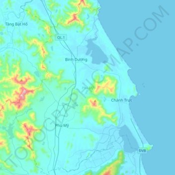
Name: Phù Mỹ District topographic map, elevation, terrain.
Location: Phù Mỹ District, Xã Bình Dương, Gia Lai Province, Vietnam (14.08167 108.96442 14.40708 109.29628)
Average elevation: 63 m
Minimum elevation: -2 m
Maximum elevation: 815 m
Thank you for supporting this site ❤️
Make a donation
Make a donation
Gear up for your next adventure:
As an Amazon Associate, this site earns from qualifying purchases at no extra cost to you.