
Thank you for supporting this site ❤️
Make a donation
Make a donation
Gear up for your next adventure:
As an Amazon Associate, this site earns from qualifying purchases at no extra cost to you.
Pleiku topographic map
Click on the map to display elevation.
Thank you for supporting this site ❤️
Make a donation
Make a donation
Gear up for your next adventure:
As an Amazon Associate, this site earns from qualifying purchases at no extra cost to you.
About this map
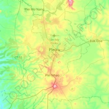
Name: Pleiku topographic map, elevation, terrain.
Location: Pleiku, Hoi Phu Ward, Xã Biển Hồ, Gia Lai Province, Vietnam (13.83408 107.83873 14.08711 108.09893)
Average elevation: 725 m
Minimum elevation: 579 m
Maximum elevation: 1,017 m
Thank you for supporting this site ❤️
Make a donation
Make a donation
Gear up for your next adventure:
As an Amazon Associate, this site earns from qualifying purchases at no extra cost to you.