
Make a donation
Gear up for your next adventure:
As an Amazon Associate, this site earns from qualifying purchases at no extra cost to you.
Lào Cai Province topographic map
Click on the map to display elevation.
Make a donation
Gear up for your next adventure:
As an Amazon Associate, this site earns from qualifying purchases at no extra cost to you.
Lào Cai Province
There are ten major soil groups under 30 categories in the province, under ten land groups. The land groups are: The Alluvial group (1.47% of the land area) along the Red River is good for growing food crops and trees; the Oxisol type which occupies 40% of land area has generally reddish brown soil, below altitude of 900 metres (3,000 ft), is a fertile land suitable for the annual and commercial crops; Team Red Yellow soil humus covers 30% land area in the Sa Pa, Mường Khương, Bắc Hà, Bát Xát districts of the province suitable for medicinal plants, fruit trees and vegetables; humus soil on the mountain occupies 11.42% of the land area mostly in Sa Pa district which has rich canopy of mixed forest; and the Oxisol color altered by rice in 2% of land area are formed into a landscape of terraced fields, as seen in Bắc Hà and Sa Pa districts.
Make a donation
Gear up for your next adventure:
As an Amazon Associate, this site earns from qualifying purchases at no extra cost to you.
About this map
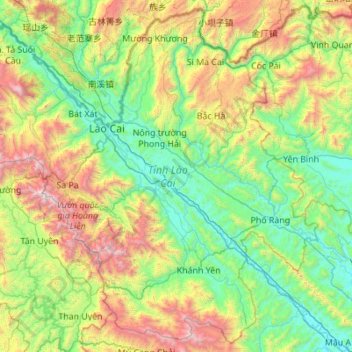
Name: Lào Cai Province topographic map, elevation, terrain.
Location: Lào Cai Province, Vietnam (21.32592 103.52943 22.84492 105.10038)
Average elevation: 789 m
Minimum elevation: 23 m
Maximum elevation: 3,056 m
Make a donation
Gear up for your next adventure:
As an Amazon Associate, this site earns from qualifying purchases at no extra cost to you.
Other topographic maps
Click on a map to view its topography, its elevation and its terrain.
Ho Chi Minh City
Ho Chi Minh City is located in the south-eastern region of Vietnam, 1,760 km (1,090 mi) south of Hanoi. The average elevation is 5 m (16 ft) above sea level for the city center and 16 m (52 ft) for the suburb areas. It borders Tây Ninh Province and Bình Dương Province to the north, Đồng Nai Province and…
Average elevation: 6 m
Make a donation
Gear up for your next adventure:
As an Amazon Associate, this site earns from qualifying purchases at no extra cost to you.
Huế
Vietnam > Huế > Thuận Hóa Ward
The Perfume River (called Sông Hương or Hương Giang in Vietnamese) passes through the center of the city. The city also accommodates the Tam Giang–Cau Hai lagoon, the largest lagoon in Southeast Asia, which is 68 kilometres (42 mi) long with a surface area of 220 square kilometres (85 sq mi). The city…
Average elevation: 30 m
quang truong dai doan ket
Vietnam > Gia Lai Province > Phường Pleiku > Pleiku Ward
Average elevation: 755 m
Make a donation
Gear up for your next adventure:
As an Amazon Associate, this site earns from qualifying purchases at no extra cost to you.
Make a donation
Gear up for your next adventure:
As an Amazon Associate, this site earns from qualifying purchases at no extra cost to you.
Make a donation
Gear up for your next adventure:
As an Amazon Associate, this site earns from qualifying purchases at no extra cost to you.
Make a donation
Gear up for your next adventure:
As an Amazon Associate, this site earns from qualifying purchases at no extra cost to you.
Make a donation
Gear up for your next adventure:
As an Amazon Associate, this site earns from qualifying purchases at no extra cost to you.
Make a donation
Gear up for your next adventure:
As an Amazon Associate, this site earns from qualifying purchases at no extra cost to you.
Make a donation
Gear up for your next adventure:
As an Amazon Associate, this site earns from qualifying purchases at no extra cost to you.
Make a donation
Gear up for your next adventure:
As an Amazon Associate, this site earns from qualifying purchases at no extra cost to you.
Make a donation
Gear up for your next adventure:
As an Amazon Associate, this site earns from qualifying purchases at no extra cost to you.
Yersin Park
Vietnam > Lâm Đồng Province > Phường Xuân Hương - Đà Lạt > Da Lat
Average elevation: 1,482 m
Make a donation
Gear up for your next adventure:
As an Amazon Associate, this site earns from qualifying purchases at no extra cost to you.
Make a donation
Gear up for your next adventure:
As an Amazon Associate, this site earns from qualifying purchases at no extra cost to you.
Make a donation
Gear up for your next adventure:
As an Amazon Associate, this site earns from qualifying purchases at no extra cost to you.
Make a donation
Gear up for your next adventure:
As an Amazon Associate, this site earns from qualifying purchases at no extra cost to you.
Make a donation
Gear up for your next adventure:
As an Amazon Associate, this site earns from qualifying purchases at no extra cost to you.
Sa Pa
Vietnam > Lao Cai province > Sa Pa
Sa Pa District is in Lào Cai Province, northwest Vietnam, 380 km northwest of Hanoi close to the border with China. The Hoàng Liên Son range of mountains dominates the district, which is at the eastern extremity of the Himalayas. This range includes Vietnam's highest mountain, Fan Si Pan, at a height of…
Average elevation: 1,520 m
Make a donation
Gear up for your next adventure:
As an Amazon Associate, this site earns from qualifying purchases at no extra cost to you.
Quy Nhơn
Vietnam > Gia Lai Province > Phường Quy Nhơn
Quy Nhon has a varied topography, being extremely diversified with mountains and forests, hills, fields, salt marshes, plains, lagoons, lakes, rivers, shorelines, peninsulas and islands. Its coastline is 42 kilometres or 26 miles long with sandy beaches, abundant seafood resources and other natural products of…
Average elevation: 58 m
Ba Den Mountain
Vietnam > Tay Ninh province > Phường Bình Minh
In early December 1974 heavy combat in Tây Ninh began, with People's Army of Vietnam (PAVN) rockets falling on the province capital and on adjacent military installations. The 80-man 3rd Company, 314th Regional Force Battalion guarding the radio relay station on the summit of Nui Ba Den began receiving…
Average elevation: 441 m
Make a donation
Gear up for your next adventure:
As an Amazon Associate, this site earns from qualifying purchases at no extra cost to you.
Make a donation
Gear up for your next adventure:
As an Amazon Associate, this site earns from qualifying purchases at no extra cost to you.
Make a donation
Gear up for your next adventure:
As an Amazon Associate, this site earns from qualifying purchases at no extra cost to you.
Make a donation
Gear up for your next adventure:
As an Amazon Associate, this site earns from qualifying purchases at no extra cost to you.
Công Viên Trường Đại Học Phú Yên
Vietnam > Đắk Lắk province > Phường Tuy Hòa > Tuy Hòa
Average elevation: 6 m
Make a donation
Gear up for your next adventure:
As an Amazon Associate, this site earns from qualifying purchases at no extra cost to you.
Fansipan Mountain Peak
Vietnam > Lai Chau province > Xã Mường Khoa
Fansipan is the tallest mountain in the Hoang Lien Son range, situated on the border of Lào Cai and Lai Châu provinces, with its peak located on the Lào Cai side. The mountain is part of Hoàng Liên National Park. It has a topographic prominence of 1,617 metres (5,305 ft), ranking sixth in Vietnam.
Average elevation: 2,616 m
Make a donation
Gear up for your next adventure:
As an Amazon Associate, this site earns from qualifying purchases at no extra cost to you.
Make a donation
Gear up for your next adventure:
As an Amazon Associate, this site earns from qualifying purchases at no extra cost to you.
Make a donation
Gear up for your next adventure:
As an Amazon Associate, this site earns from qualifying purchases at no extra cost to you.
Hạ Long Bay
Vietnam > Quang Ninh Province > Ha Long
Due to a simultaneous combination of ideal factors such as thick, pale, grey, and strong limestone layers, which are formed by fine-grained materials; hot and moist climate and slow tectonic process as a whole; Hạ Long Bay has had a complete karst evolution for 20 million years. There are many types of karst…
Average elevation: 0 m
Yersin Park
Vietnam > Lâm Đồng Province > Phường Xuân Hương - Đà Lạt > Da Lat
Average elevation: 1,482 m
Make a donation
Gear up for your next adventure:
As an Amazon Associate, this site earns from qualifying purchases at no extra cost to you.