
Make a donation
Gear up for your next adventure:
As an Amazon Associate, this site earns from qualifying purchases at no extra cost to you.
Boavita topographic map
Click on the map to display elevation.
Make a donation
Gear up for your next adventure:
As an Amazon Associate, this site earns from qualifying purchases at no extra cost to you.
Boavita
Boavita is a town and municipality in the Colombian Department of Boyacá, part of the subregion of the Northern Boyacá Province. The urban centre of Boavita is situated in the Eastern Ranges of the Colombian Andes at an altitude of 2,114 metres (6,936 ft) and a distance of 184 kilometres (114 mi) from the department capital Tunja. The municipality borders Capitanejo, Santander, and the Nevado River in the north, San Mateo and La Uvita in the east, Tipacoque and Soatá in the west and Susacón in the south.
Make a donation
Gear up for your next adventure:
As an Amazon Associate, this site earns from qualifying purchases at no extra cost to you.
About this map
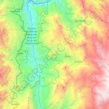
Name: Boavita topographic map, elevation, terrain.
Location: Boavita, Norte, Boyacá, 151060, Colombia (6.22068 -72.66525 6.44412 -72.56642)
Average elevation: 2,435 m
Minimum elevation: 1,169 m
Maximum elevation: 4,133 m
Make a donation
Gear up for your next adventure:
As an Amazon Associate, this site earns from qualifying purchases at no extra cost to you.
Other topographic maps
Click on a map to view its topography, its elevation and its terrain.
Sogamoso
Sogamoso (Spanish pronunciation: [soɣaˈmoso]) is a city in the department of Boyacá of Colombia. It is the capital of the Sugamuxi Province, named after the original Sugamuxi. Sogamoso is nicknamed "City of the Sun", based on the original Muisca tradition of pilgrimage and adoring their Sun god Sué at the…
Average elevation: 2,901 m
Cordillera Oriental
The Cordillera Oriental montane forests ecoregion covers the eastern slopes of the cordillera and its northern end. The Magdalena Valley montane forests cover the western slopes. The Northern Andean páramo covers the highest elevations.
Average elevation: 4,825 m
Guateque
Guateque is a town and municipality in the Colombian Department of Boyacá, part of the subregion of the Eastern Boyacá Province. Guateque's urban center is located at an altitude of 1,815 metres (5,955 ft) on the Altiplano Cundiboyacense at distances of 125 kilometres (78 mi) from the department capital…
Average elevation: 1,790 m
Make a donation
Gear up for your next adventure:
As an Amazon Associate, this site earns from qualifying purchases at no extra cost to you.
Paipa
Colombia > Boyacá > Paipa > Paipa
Paipa is located 15 km west of Duitama and 48 kilometres (30 mi) to the northeast of Tunja, the capital of the department, in the Cordillera Oriental (Eastern Ranges) of the Colombian Andes. It is the main tourist center of the region, with a number of large hotels and hot springs. At an elevation of 2525 m,…
Average elevation: 2,641 m
Make a donation
Gear up for your next adventure:
As an Amazon Associate, this site earns from qualifying purchases at no extra cost to you.