Geolocate

Lenoir topographic map

Click on the map to display elevation.

About this map

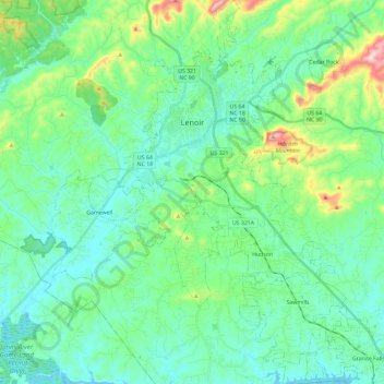
Name: Lenoir topographic map, elevation, terrain.

Location: Lenoir, Caldwell County, North Carolina, 28645, United States (35.78379 -81.59380 35.97491 -81.46398)

Average elevation: 381 m

Minimum elevation: 300 m

Maximum elevation: 683 m

Other topographic maps

Click on a map to view its topography, its elevation and its terrain.

Upton

United States > North Carolina > Caldwell County

Average elevation: 536 m

Globe

United States > North Carolina > Caldwell County

Average elevation: 489 m

Piney

United States > North Carolina > Caldwell County

Average elevation: 377 m

Globe

United States > North Carolina > Caldwell County

Average elevation: 489 m

Warrior

United States > North Carolina > Caldwell County

Average elevation: 431 m

Gear up for your next adventure:

🧊Portable Cooler - Keep food and drinks cold during outdoor adventures
🧰Survival Kit - Essential gear for emergencies in the wilderness
🧭GPS Handheld Device - Reliable GPS navigation for outdoor adventures
🩹Compact First Aid Kit - Pre-packed essentials for common trail injuries
💡Solar Camping Lamp - Eco-friendly lighting for campsites

As an Amazon Associate, this site earns from qualifying purchases at no extra cost to you.