Geolocate

Warrior topographic map

Click on the map to display elevation.

About this map

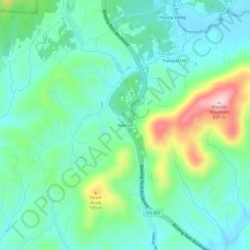
Name: Warrior topographic map, elevation, terrain.

Location: Warrior, Caldwell County, North Carolina, United States (35.95143 -81.58809 35.99143 -81.54809)

Average elevation: 431 m

Minimum elevation: 360 m

Maximum elevation: 632 m

Other topographic maps

Click on a map to view its topography, its elevation and its terrain.

Lenoir

United States > North Carolina > Caldwell County

Average elevation: 381 m

Lenoir

United States > North Carolina > Caldwell County

Average elevation: 381 m

Gear up for your next adventure:

🧥Ultralight Puffy Jacket - Maximum warmth that packs down to the size of an orange
🧰Emergency Multi-Tool - Compact multi-tool for outdoor survival
🧥Waterproof Hiking Jacket - Protect yourself from rain and wind while hiking
🥾Trail Hiking Shoes - Durable shoes designed for rugged trails
🥾All-Terrain Hiking Boots - Versatile boots for varied hiking conditions

As an Amazon Associate, this site earns from qualifying purchases at no extra cost to you.