Geolocate

Frenchtown topographic map

Click on the map to display elevation.

About this map

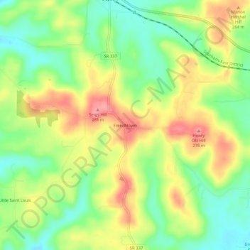
Name: Frenchtown topographic map, elevation, terrain.

Location: Frenchtown, Harrison County, Indiana, 47115, United States (38.29479 -86.23442 38.33479 -86.19442)

Average elevation: 231 m

Minimum elevation: 188 m

Maximum elevation: 279 m

Other topographic maps

Click on a map to view its topography, its elevation and its terrain.

Corydon

United States > Indiana > Harrison County

Average elevation: 196 m

Elizabeth

United States > Indiana > Harrison County

Average elevation: 236 m

Mauckport

United States > Indiana > Harrison County

Average elevation: 146 m

Palmyra

United States > Indiana > Harrison County

Average elevation: 236 m

Lanesville

United States > Indiana > Harrison County

Average elevation: 239 m

Crandall

United States > Indiana > Harrison County

Average elevation: 217 m

Gear up for your next adventure:

🔭Outdoor Binoculars - Lightweight binoculars for birdwatching and hiking
🔨Vehicle Emergency Tool - Safety tool for remote road trips to trailheads
🛌Insulated Sleeping Pad - Critical thermal barrier between you and the cold ground
🥾Hiking Boots - Sturdy boots providing ankle support and traction on rugged trails
🧰Multitool Knife - Compact and versatile tool for outdoor use

As an Amazon Associate, this site earns from qualifying purchases at no extra cost to you.