Geolocate

Corydon topographic map

Click on the map to display elevation.

About this map

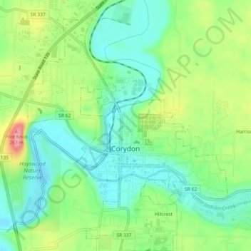
Name: Corydon topographic map, elevation, terrain.

Location: Corydon, Harrison County, Indiana, United States (38.19843 -86.14351 38.23382 -86.10701)

Average elevation: 196 m

Minimum elevation: 157 m

Maximum elevation: 265 m

Other topographic maps

Click on a map to view its topography, its elevation and its terrain.

Sugar Grove

United States > Indiana > Harrison County

Average elevation: 171 m

Macedonia

United States > Indiana > Harrison County

Average elevation: 224 m

Frenchtown

United States > Indiana > Harrison County

Average elevation: 231 m

Hillcrest

United States > Indiana > Harrison County > Corydon

Average elevation: 200 m

Gear up for your next adventure:

🕶️Polarized Sunglasses - Reduces glare from snow and water at high elevations
🧥Thermal Layer - Insulating layer for cold outdoor conditions
🩹Moleskin Blister Pads - Direct protection for painful foot pressure points
🗺️Topographic Maps - Detailed maps to explore trails, mountains, and wilderness areas
🧥Ultralight Puffy Jacket - Maximum warmth that packs down to the size of an orange

As an Amazon Associate, this site earns from qualifying purchases at no extra cost to you.