Geolocate

Lanesville topographic map

Click on the map to display elevation.

About this map

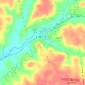
Name: Lanesville topographic map, elevation, terrain.

Location: Lanesville, Harrison County, Indiana, United States (38.22690 -85.99271 38.24323 -85.97753)

Average elevation: 239 m

Minimum elevation: 204 m

Maximum elevation: 272 m

Other topographic maps

Click on a map to view its topography, its elevation and its terrain.

Macedonia

United States > Indiana > Harrison County

Average elevation: 224 m

Frenchtown

United States > Indiana > Harrison County

Average elevation: 231 m

Hillcrest

United States > Indiana > Harrison County > Corydon

Average elevation: 200 m

Gear up for your next adventure:

🧦Crew Hiking Socks - Comfortable socks for long-distance hikes
Camping Tent - Weather-resistant tents suitable for 2 to 6 people
💡LED Headlamp - Hands-free illumination for night hiking and camping
🔦UV Flashlight - Detect minerals or specific insects in the dark
🔭Compact Binoculars - Lightweight optics for scouting trails and wildlife

As an Amazon Associate, this site earns from qualifying purchases at no extra cost to you.