
Make a donation
Gear up for your next adventure:
As an Amazon Associate, this site earns from qualifying purchases at no extra cost to you.
Ramapo topographic map
Click on the map to display elevation.
Make a donation
Gear up for your next adventure:
As an Amazon Associate, this site earns from qualifying purchases at no extra cost to you.
About this map
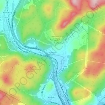
Name: Ramapo topographic map, elevation, terrain.
Average elevation: 191 m
Minimum elevation: 86 m
Maximum elevation: 359 m
Make a donation
Gear up for your next adventure:
As an Amazon Associate, this site earns from qualifying purchases at no extra cost to you.
Other topographic maps
Click on a map to view its topography, its elevation and its terrain.
Bear Mountain State Park
United States > New York > Rockland County > Town of Stony Point
There are over 50 official trails covering 235 miles (378 km), featuring a wide range of difficulties and elevation changes.
Average elevation: 166 m
Make a donation
Gear up for your next adventure:
As an Amazon Associate, this site earns from qualifying purchases at no extra cost to you.
Palisades
United States > New York > Rockland County > Sparkill
In 1800 the population of Palisades was 114. Because of the local topography the town was well suited to become a river center. Rising from the west bank of the Hudson River, the Palisades Cliff forms an obstacle to transport seeking access to the river. A break in the terrain occurs at Palisades, still known…
Average elevation: 28 m
Town of Ramapo
United States > New York > Rockland County
Torne Mountain (1,130 ft or 340 m; shown on topographic maps as "High Torne"), in Harriman State Park, overlooks the Ramapo Pass and remnants of the once-thriving Ramapo Iron Works. During the American Revolution, the Torne served as a lookout for British ship movements on the Hudson. Legend tells that Gen.…
Average elevation: 173 m
Make a donation
Gear up for your next adventure:
As an Amazon Associate, this site earns from qualifying purchases at no extra cost to you.
Make a donation
Gear up for your next adventure:
As an Amazon Associate, this site earns from qualifying purchases at no extra cost to you.
Make a donation
Gear up for your next adventure:
As an Amazon Associate, this site earns from qualifying purchases at no extra cost to you.
Palisades
United States > New York > Rockland County > Sparkill
In 1800 the population of Palisades was 114. Because of the local topography the town was well suited to become a river center. Rising from the west bank of the Hudson River, the Palisades Cliff forms an obstacle to transport seeking access to the river. A break in the terrain occurs at Palisades, still known…
Average elevation: 29 m
Nanuet
United States > New York > Rockland County > Nanuet
The topography is a result of the massive glaciation of the last ice age, and as such the soil is extremely rocky and the surface shows glacial erratic boulders. The glacial ice scraped off and carried with it rocks and minerals from as far north as Canada, depositing them in Nanuet in particular and southern…
Average elevation: 104 m
Make a donation
Gear up for your next adventure:
As an Amazon Associate, this site earns from qualifying purchases at no extra cost to you.
Palisades
United States > New York > Rockland County > Sparkill
In 1800 the population of Palisades was 114. Because of the local topography the town was well suited to become a river center. Rising from the west bank of the Hudson River, the Palisades Cliff forms an obstacle to transport seeking access to the river. A break in the terrain occurs at Palisades, still known…
Average elevation: 29 m
Make a donation
Gear up for your next adventure:
As an Amazon Associate, this site earns from qualifying purchases at no extra cost to you.
Make a donation
Gear up for your next adventure:
As an Amazon Associate, this site earns from qualifying purchases at no extra cost to you.