
Make a donation
Gear up for your next adventure:
As an Amazon Associate, this site earns from qualifying purchases at no extra cost to you.
Village of Chestnut Ridge topographic map
Click on the map to display elevation.
Make a donation
Gear up for your next adventure:
As an Amazon Associate, this site earns from qualifying purchases at no extra cost to you.
About this map
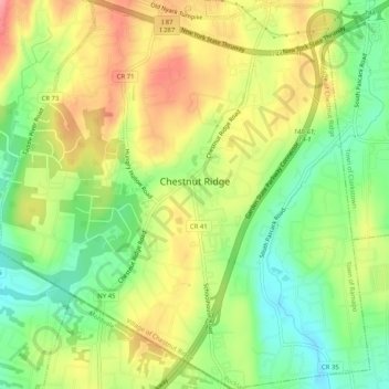
Name: Village of Chestnut Ridge topographic map, elevation, terrain.
Average elevation: 127 m
Minimum elevation: 80 m
Maximum elevation: 179 m
Make a donation
Gear up for your next adventure:
As an Amazon Associate, this site earns from qualifying purchases at no extra cost to you.
Other topographic maps
Click on a map to view its topography, its elevation and its terrain.
Garnerville
United States > New York > Rockland County > Village of West Haverstraw
Average elevation: 80 m
Make a donation
Gear up for your next adventure:
As an Amazon Associate, this site earns from qualifying purchases at no extra cost to you.
Fort Clinton
United States > New York > Rockland County > Town of Stony Point
Average elevation: 111 m
Garnerville
United States > New York > Rockland County > Village of West Haverstraw
Average elevation: 80 m
Make a donation
Gear up for your next adventure:
As an Amazon Associate, this site earns from qualifying purchases at no extra cost to you.
Antrim
United States > New York > Rockland County > Town of Ramapo > Village of Suffern
Average elevation: 140 m