Geolocate

New City topographic map

Click on the map to display elevation.

About this map

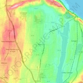
Name: New City topographic map, elevation, terrain.

Location: New City, Town of Clarkstown, Rockland County, New York, 10956, United States (41.10742 -74.02526 41.19250 -73.94381)

Average elevation: 89 m

Minimum elevation: 0 m

Maximum elevation: 231 m

Other topographic maps

Click on a map to view its topography, its elevation and its terrain.

Centenary

United States > New York > Rockland County > New City

Average elevation: 55 m

Gear up for your next adventure:

🌬️Windproof Camp Stove - Efficient cooking even on exposed mountain peaks
💧Hydration Bladder - Hands-free hydration solution for long treks
🧴Bear Spray Holster - Quick-access carry for essential Canadian wilderness safety
🥫Freeze-Dried Meals - Lightweight, high-calorie nutrition for multi-day treks
🕶️Polarized Sunglasses - Reduces glare from snow and water at high elevations

As an Amazon Associate, this site earns from qualifying purchases at no extra cost to you.