Geolocate

Estero topographic map

Click on the map to display elevation.

About this map

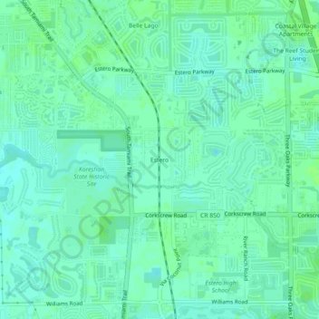
Name: Estero topographic map, elevation, terrain.

Location: Estero, Lee County, Florida, 33928, United States (26.41815 -81.82675 26.45815 -81.78675)

Average elevation: 7 m

Minimum elevation: 2 m

Maximum elevation: 10 m

Other topographic maps

Click on a map to view its topography, its elevation and its terrain.

San Carlos Park

United States > Florida > Lee County

Average elevation: 7 m

Citris Canal

United States > Florida > Lee County > Cape Coral

Average elevation: 3 m

Alva

United States > Florida > Lee County > Alva

Average elevation: 7 m

Bonita Springs

United States > Florida > Lee County

Average elevation: 5 m

Olga

United States > Florida > Lee County

Average elevation: 6 m

Cape Coral

United States > Florida > Lee County

Average elevation: 4 m

Iona

United States > Florida > Lee County

Average elevation: 2 m

Gear up for your next adventure:

🧦Merino Wool Socks - Moisture-wicking comfort for long-distance hiking
🧰Survival Kit - Essential gear for emergencies in the wilderness
Lightweight Backpacking Tent - Compact tent for efficient hiking trips
🧤Thermal Hiking Gloves - Grip-enhanced gloves for cold-weather altitude trekking
🧥Thermal Fleece Jacket - Versatile insulation for changing mountain temperatures

As an Amazon Associate, this site earns from qualifying purchases at no extra cost to you.