Geolocate

Kediri topographic map

Click on the map to display elevation.

About this map

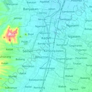
Name: Kediri topographic map, elevation, terrain.

Location: Kediri, East Java, Java, Indonesia (-7.87285 111.95441 -7.77140 112.08082)

Average elevation: 97 m

Minimum elevation: 54 m

Maximum elevation: 496 m

Other topographic maps

Click on a map to view its topography, its elevation and its terrain.

Sempolan

Indonesia > East Java > Jember

Average elevation: 327 m

Ngadipuro

Indonesia > East Java > Blitar

Average elevation: 64 m

Gunung Buthak Kawi

Indonesia > East Java > Blitar

Average elevation: 2,424 m

Caribbean Island

Indonesia > East Java > Surabaya

Average elevation: 0 m

Gear up for your next adventure:

🪑Ultralight Camping Stool - Compact seating for rest stops during long hikes
🥫Freeze-Dried Meals - Lightweight, high-calorie nutrition for multi-day treks
🧥Thermal Fleece Jacket - Versatile insulation for changing mountain temperatures
Lightweight Camping Tent - Portable shelter optimized for Canadian backcountry camping
🥾Hiking Gaiters - Protect legs and shoes from mud, snow, and debris

As an Amazon Associate, this site earns from qualifying purchases at no extra cost to you.