
Avalon Peninsula topographic map
Click on the map to display elevation.
About this map
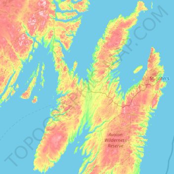
Name: Avalon Peninsula topographic map, elevation, terrain.
Location: Avalon Peninsula, Newfoundland and Labrador, Canada (46.78924 -54.20189 48.17342 -52.84891)
Average elevation: 69 m
Minimum elevation: -2 m
Maximum elevation: 373 m
Newfoundland and Labrador trails, hiking, mountain biking, running and outdoor activities
Other topographic maps
Click on a map to view its topography, its elevation and its terrain.
Signal Hill National Historic Site
Canada > Newfoundland and Labrador > St. John's
Average elevation: 29 m
Pollards Point
Canada > Newfoundland and Labrador > unincorporated Newfoundland > Pollards Point
Average elevation: 32 m
Avalon Peninsula
Canada > Newfoundland and Labrador > Spaniard's Bay > Tilton
Average elevation: 157 m
Ferryland Head
Canada > Newfoundland and Labrador > unincorporated Newfoundland > Ferryland
Average elevation: 1 m
Table Mountains
Canada > Newfoundland and Labrador > unincorporated Newfoundland
Average elevation: 37 m
Cape St. George
Canada > Newfoundland and Labrador > Cape St. George > Cape St. George
Average elevation: 68 m
Middle Cove
Canada > Newfoundland and Labrador > Logy Bay-Middle Cove-Outer Cove
Average elevation: 41 m