
Groton topographic map
Click on the map to display elevation.
About this map
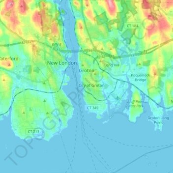
Name: Groton topographic map, elevation, terrain.
Average elevation: 21 m
Minimum elevation: -4 m
Maximum elevation: 111 m
Other topographic maps
Click on a map to view its topography, its elevation and its terrain.
High Rock
United States > Connecticut > Southeastern Connecticut Planning Region > Waterford
Average elevation: 39 m
Chesterfield
United States > Connecticut > Southeastern Connecticut Planning Region > Montville
Average elevation: 77 m
North Franklin
United States > Connecticut > Southeastern Connecticut Planning Region
Average elevation: 103 m
Flanders
United States > Connecticut > Southeastern Connecticut Planning Region > East Lyme
Average elevation: 43 m
Manitock Spring
United States > Connecticut > Southeastern Connecticut Planning Region > Waterford
Average elevation: 26 m
Quiambaug
United States > Connecticut > Southeastern Connecticut Planning Region > Mystic
Average elevation: 8 m
Oakdale
United States > Connecticut > Southeastern Connecticut Planning Region > Montville
Average elevation: 141 m
Austrailia Beach
United States > Connecticut > Southeastern Connecticut Planning Region > Mystic
Average elevation: 19 m
Jordan Village
United States > Connecticut > Southeastern Connecticut Planning Region > Waterford
Average elevation: 27 m
Giants Neck
United States > Connecticut > Southeastern Connecticut Planning Region > East Lyme
Average elevation: 9 m
Cohanzie
United States > Connecticut > Southeastern Connecticut Planning Region > Waterford
Average elevation: 50 m
Allyn Point
United States > Connecticut > Southeastern Connecticut Planning Region > Ledyard > Gales Ferry
Average elevation: 34 m
Austrailia Beach
United States > Connecticut > Southeastern Connecticut Planning Region > Mystic
Average elevation: 19 m
Quaker Hill
United States > Connecticut > Southeastern Connecticut Planning Region > Waterford
Average elevation: 35 m
Uncasville
United States > Connecticut > Southeastern Connecticut Planning Region > Montville
Average elevation: 40 m
Flanders
United States > Connecticut > Southeastern Connecticut Planning Region > East Lyme
Average elevation: 38 m
Austrailia Beach
United States > Connecticut > Southeastern Connecticut Planning Region > Mystic
Average elevation: 19 m
Pepperbox Hill
United States > Connecticut > Southeastern Connecticut Planning Region > Waterford
Average elevation: 18 m
Montville Center
United States > Connecticut > Southeastern Connecticut Planning Region > Montville
Average elevation: 106 m
Mystic
United States > Connecticut > Southeastern Connecticut Planning Region > Stonington
Average elevation: 17 m
Chesterfield
United States > Connecticut > Southeastern Connecticut Planning Region > Montville
Average elevation: 77 m
Austrailia Beach
United States > Connecticut > Southeastern Connecticut Planning Region > Mystic
Average elevation: 19 m
Huntley Island
United States > Connecticut > Southeastern Connecticut Planning Region > East Lyme
Average elevation: 7 m
Fitch Corner
United States > Connecticut > Southeastern Connecticut Planning Region > Montville
Average elevation: 51 m
Four Corners
United States > Connecticut > Southeastern Connecticut Planning Region > Montville
Average elevation: 108 m
Quiambaug
United States > Connecticut > Southeastern Connecticut Planning Region > Mystic
Average elevation: 8 m
Avery Hill
United States > Connecticut > Southeastern Connecticut Planning Region > Ledyard
Average elevation: 52 m
Center Groton
United States > Connecticut > Southeastern Connecticut Planning Region > Groton
Average elevation: 49 m
Austrailia Beach
United States > Connecticut > Southeastern Connecticut Planning Region > Mystic
Average elevation: 19 m
Hanover Reservoir
United States > Connecticut > Southeastern Connecticut Planning Region > Hanover
Average elevation: 91 m
Taftville Reservoir #1 Dam
United States > Connecticut > Southeastern Connecticut Planning Region > Norwich
Average elevation: 75 m
Blue Lake
United States > Connecticut > Southeastern Connecticut Planning Region > North Stonington
Average elevation: 106 m
Blackboys
United States > Connecticut > Southeastern Connecticut Planning Region > East Lyme
Average elevation: 38 m
North Stonington
United States > Connecticut > Southeastern Connecticut Planning Region
Average elevation: 73 m
Seal Rocks
United States > Connecticut > Southeastern Connecticut Planning Region > Stonington
Average elevation: 37 m