Geolocate

Menaggio topographic map

Click on the map to display elevation.

About this map

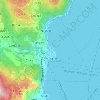
Name: Menaggio topographic map, elevation, terrain.

Location: Menaggio, Como, Lombardy, 22017, Italy (46.00479 9.19787 46.04274 9.26687)

Average elevation: 350 m

Minimum elevation: 190 m

Maximum elevation: 1,045 m

Other topographic maps

Click on a map to view its topography, its elevation and its terrain.

San Fedele Intelvi

Italy > Lombardy > Como

Average elevation: 828 m

Carcente

Italy > Lombardy > Como > San Siro > Acquaseria

Average elevation: 693 m

Auvrascio

Italy > Lombardy > Como > Schignano > Occagno

Average elevation: 769 m

Lenno

Italy > Lombardy > Como > Tremezzina

Average elevation: 382 m

Lanzo d'Intelvi

Italy > Lombardy > Como

Average elevation: 863 m

Rovenna

Italy > Lombardy > Como

Average elevation: 449 m

Dicinisio

Italy > Lombardy > Como

Average elevation: 831 m

Naggio

Italy > Lombardy > Como > Grandola ed Uniti

Average elevation: 651 m

San Giorgio

Italy > Lombardy > Como > Solbiate con Cagno > Concagno

Average elevation: 400 m

Casasco d'Intelvi

Italy > Lombardy > Como

Average elevation: 853 m

Parè

Italy > Lombardy > Como > Colverde

Average elevation: 386 m

Gear up for your next adventure:

🧦Crew Hiking Socks - Comfortable socks for long-distance hikes
🥾Waterproof Trail Shoes - Shoes designed to handle wet terrain
🧰Survival Kit - Essential gear for emergencies in the wilderness
🧥Insulated Jacket - Keep warm in cold outdoor conditions
🦶Anti-Blister Balm - Prevents friction and hotspots during long ascents

As an Amazon Associate, this site earns from qualifying purchases at no extra cost to you.