Geolocate

Lovejoy topographic map

Click on the map to display elevation.

About this map

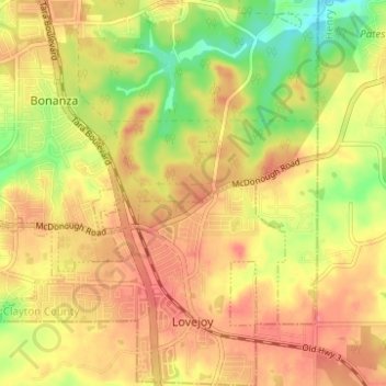
Name: Lovejoy topographic map, elevation, terrain.

Location: Lovejoy, Clayton County, Georgia, United States (33.42743 -84.34524 33.47903 -84.29696)

Average elevation: 275 m

Minimum elevation: 234 m

Maximum elevation: 302 m

Other topographic maps

Click on a map to view its topography, its elevation and its terrain.

Irondale

United States > Georgia > Clayton County

Average elevation: 269 m

Conley

United States > Georgia > Clayton County

Average elevation: 270 m

Bonanza

United States > Georgia > Clayton County

Average elevation: 272 m

Gear up for your next adventure:

🧭GPS Outdoor Watch - Smart watch for navigation and fitness tracking in nature
🔥Camping Stove - Portable stoves to cook outdoors with ease
🧥Waterproof Jacket - Lightweight rain jackets for hiking and outdoor activities
Bushcraft Tarp - Versatile emergency shelter or gear protection
🛏️Camping Sleeping Mat - Comfortable mats for sleeping outdoors

As an Amazon Associate, this site earns from qualifying purchases at no extra cost to you.