Geolocate

Bonanza topographic map

Click on the map to display elevation.

About this map

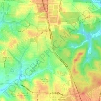
Name: Bonanza topographic map, elevation, terrain.

Location: Bonanza, Clayton County, Georgia, 30250, United States (33.44567 -84.35659 33.48567 -84.31659)

Average elevation: 272 m

Minimum elevation: 244 m

Maximum elevation: 297 m

Other topographic maps

Click on a map to view its topography, its elevation and its terrain.

Morrow

United States > Georgia > Clayton County

Average elevation: 276 m

Riverdale

United States > Georgia > Clayton County

Average elevation: 272 m

Jonesboro

United States > Georgia > Clayton County

Average elevation: 269 m

Lovejoy

United States > Georgia > Clayton County

Average elevation: 275 m

Gear up for your next adventure:

🥾Approach Shoes - Shoes designed for climbing approaches and rugged trails
🔭Outdoor Binoculars - Lightweight binoculars for birdwatching and hiking
👟Leg Gaiters - Keep debris, mud, and snow out of your boots
🔨Vehicle Emergency Tool - Safety tool for remote road trips to trailheads
🧥Ultralight Puffy Jacket - Maximum warmth that packs down to the size of an orange

As an Amazon Associate, this site earns from qualifying purchases at no extra cost to you.