Geolocate

Irondale topographic map

Click on the map to display elevation.

About this map

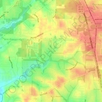
Name: Irondale topographic map, elevation, terrain.

Location: Irondale, Clayton County, Georgia, 30238, United States (33.46067 -84.37881 33.50067 -84.33881)

Average elevation: 269 m

Minimum elevation: 233 m

Maximum elevation: 295 m

Other topographic maps

Click on a map to view its topography, its elevation and its terrain.

Morrow

United States > Georgia > Clayton County

Average elevation: 276 m

Riverdale

United States > Georgia > Clayton County

Average elevation: 272 m

Jonesboro

United States > Georgia > Clayton County

Average elevation: 269 m

Lovejoy

United States > Georgia > Clayton County

Average elevation: 275 m

Gear up for your next adventure:

🧥Ultralight Puffy Jacket - Maximum warmth that packs down to the size of an orange
🥾Trail Hiking Boots - Supportive boots for rough trails
❄️Traction Ice Cleats - Slip-on spikes for icy trails and winter hiking
Family Camping Tent - Spacious tent suitable for family camping trips
🔭Compact Monocular - One-handed bird watching and trail spotting

As an Amazon Associate, this site earns from qualifying purchases at no extra cost to you.